Home > Arts > Street art graffiti > Digital art > Vector illustrations
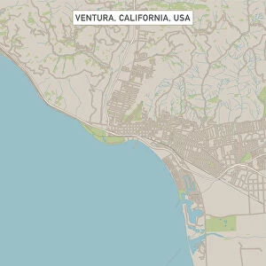
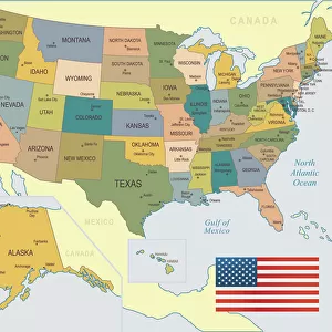
Orange California US City Street Map

![]()
Wall Art and Photo Gifts from Fine Art Storehouse
Orange California US City Street Map
Vector Illustration of a City Street Map of Orange, California, USA. Scale 1:60, 000.
All source data is in the public domain.
U.S. Geological Survey, US Topo
Used Layers:
USGS The National Map: National Hydrography Dataset (NHD)
USGS The National Map: National Transportation Dataset (NTD)
Unleash your creativity and transform your space into a visual masterpiece!
Frank Ramspott
Media ID 15055087
© Frank Ramspott, all rights reserved
Aerial View California City Map Computer Graphic Directly Above Downtown District Gray Orange Road Map Text Digitally Generated Image Green Color White Color
FEATURES IN THESE COLLECTIONS
> Aerial Photography
> Related Images
> Animals
> Insects
> Hemiptera
> Green Scale
> Animals
> Mammals
> Cricetidae
> California Mouse
> Arts
> Contemporary art
> Digital artwork
> Street art
> Arts
> Landscape paintings
> Waterfall and river artworks
> River artworks
> Arts
> Portraits
> Pop art gallery
> Street art portraits
> Arts
> Street art graffiti
> Digital art
> Digital paintings
> Arts
> Street art graffiti
> Digital art
> Vector illustrations
> Fine Art Storehouse
> Map
> Street Maps
> Fine Art Storehouse
> Map
> USA Maps
> Maps and Charts
> Geological Map
> Maps and Charts
> Related Images
EDITORS COMMENTS
This vibrant and detailed print showcases the city street map of Orange, California, USA. With a scale of 1:60,000, this vector illustration provides an accurate representation of the city's layout. The image features various elements such as the Santa Ana River, downtown district, river, lake, streets, and roads that make up this bustling urban area. Created by Frank Ramspott using publicly available data from sources like the U. S. Geological Survey (USGS) and US Topo maps, this digitally generated image is a testament to his skill in cartography and design. The use of different colors - orange for the city itself, gray for text labels and boundaries, green for natural features like parks or forests - adds visual appeal to the overall composition. With no people visible in the picture due to its focus on mapping rather than human activity or interaction, it offers a unique perspective from directly above. This aerial view allows viewers to appreciate both the physical geography of Orange as well as its intricate road network. Whether you're a resident looking to navigate your way through town or simply fascinated by maps and their artistic potential, this print is sure to captivate with its attention to detail and visually appealing design.
MADE IN THE USA
Safe Shipping with 30 Day Money Back Guarantee
FREE PERSONALISATION*
We are proud to offer a range of customisation features including Personalised Captions, Color Filters and Picture Zoom Tools
SECURE PAYMENTS
We happily accept a wide range of payment options so you can pay for the things you need in the way that is most convenient for you
* Options may vary by product and licensing agreement. Zoomed Pictures can be adjusted in the Cart.