Home > Aerial Photography > Related Images
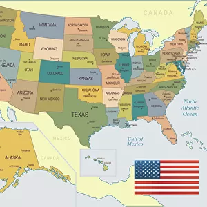
Butte Montana US City Street Map

![]()
Wall Art and Photo Gifts from Fine Art Storehouse
Butte Montana US City Street Map
Vector Illustration of a City Street Map of Butte, Montana, USA. Scale 1:60, 000.
All source data is in the public domain.
U.S. Geological Survey, US Topo
Used Layers:
USGS The National Map: National Hydrography Dataset (NHD)
USGS The National Map: National Transportation Dataset (NTD)
Unleash your creativity and transform your space into a visual masterpiece!
Frank Ramspott
Media ID 15054949
© Frank Ramspott, all rights reserved
Aerial View Butte City Map Computer Graphic Directly Above Downtown District Gray Montana Road Map Text Digitally Generated Image Green Color White Color
FEATURES IN THESE COLLECTIONS
> Aerial Photography
> Related Images
> Animals
> Insects
> Hemiptera
> Green Scale
> Arts
> Contemporary art
> Digital artwork
> Street art
> Arts
> Landscape paintings
> Waterfall and river artworks
> River artworks
> Arts
> Portraits
> Pop art gallery
> Street art portraits
> Arts
> Street art graffiti
> Digital art
> Digital paintings
> Arts
> Street art graffiti
> Digital art
> Vector illustrations
> Fine Art Storehouse
> Map
> Street Maps
> Fine Art Storehouse
> Map
> USA Maps
> Maps and Charts
> Geological Map
> Maps and Charts
> Related Images
> North America
> United States of America
> Lakes
> Related Images
EDITORS COMMENTS
This print showcases a meticulously detailed city street map of Butte, Montana, USA. With a scale of 1:60,000, every intricate aspect of this charming town is beautifully illustrated in vector format. The image encompasses the essence of Butte's unique features such as the renowned Berkeley Pit, the bustling downtown district, and its serene lake and river. The map is a result of combining various publicly available data sources including USGS The National Map: National Hydrography Dataset (NHD) and USGS The National Map: National Transportation Dataset (NTD). Expertly designed by Frank Ramspott using computer graphics technology, this digitally generated image offers an aerial view directly above the city streets. The color palette chosen for this artwork adds to its visual appeal with shades of gray, blue, white, and green seamlessly blending together. Text elements are incorporated to provide additional information about key landmarks and roads within Butte. Ideal for enthusiasts of cartography or those with a deep appreciation for urban landscapes, this print captures the physical geography and charm that make Butte truly special. It serves as both an aesthetically pleasing piece of art and a functional road map for navigation purposes. A must-have addition to any collection!
MADE IN THE USA
Safe Shipping with 30 Day Money Back Guarantee
FREE PERSONALISATION*
We are proud to offer a range of customisation features including Personalised Captions, Color Filters and Picture Zoom Tools
SECURE PAYMENTS
We happily accept a wide range of payment options so you can pay for the things you need in the way that is most convenient for you
* Options may vary by product and licensing agreement. Zoomed Pictures can be adjusted in the Cart.