Home > Maps and Charts > Early Maps
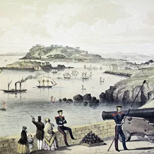
Plan of Forts and Harbour at Charlestown, 1860s

![]()
Wall Art and Photo Gifts from Fine Art Storehouse
Plan of Forts and Harbour at Charlestown, 1860s
Vintage engraving of Plan of Forts and Harbour at Charlestown, South Carolina, 1860s, 19th Century
Unleash your creativity and transform your space into a visual masterpiece!
duncan1890
Media ID 19684277
© of Duncan P Walker
FEATURES IN THESE COLLECTIONS
> Fine Art Storehouse
> Map
> Historical Maps
> Maps and Charts
> Early Maps
EDITORS COMMENTS
This vintage engraving transports us back to the 1860s, offering a glimpse into the strategic Plan of Forts and Harbour at Charlestown in South Carolina. The intricate details showcased in this print allow us to explore the historical significance of this coastal city during the 19th century. As we delve into this piece, our eyes are drawn to Fort Moultrie standing proudly amidst its surroundings. Its sturdy walls and imposing structure speak volumes about its role as a defensive stronghold guarding Charleston's harbor. The meticulous rendering captures every architectural nuance, highlighting the fort's formidable presence against the backdrop of an expansive waterway. The artist's skillful use of line work and shading brings depth and dimension to this engraving, inviting us to imagine what life was like within these historic walls. We can almost envision soldiers patrolling their posts or cannons being readied for potential threats from enemy ships on the horizon. Beyond its aesthetic appeal, this print serves as a valuable historical artifact that sheds light on Charleston's rich maritime heritage. It offers viewers an opportunity to appreciate not only the artistry involved but also gain insight into how forts played a crucial role in safeguarding important harbors during times of conflict. Duncan1890 has masterfully preserved this slice of history through his artistic interpretation, allowing us to connect with Charleston's past while appreciating it as a timeless piece of fine art.
MADE IN THE USA
Safe Shipping with 30 Day Money Back Guarantee
FREE PERSONALISATION*
We are proud to offer a range of customisation features including Personalised Captions, Color Filters and Picture Zoom Tools
SECURE PAYMENTS
We happily accept a wide range of payment options so you can pay for the things you need in the way that is most convenient for you
* Options may vary by product and licensing agreement. Zoomed Pictures can be adjusted in the Cart.