Home > Europe > United Kingdom > England > London > Museums > National Maritime Museum
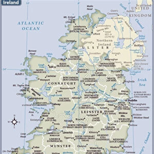
A new map of Ireland civil and ecclesiastical, 1797 (manuscript)
")
![]()
Wall Art and Photo Gifts from Fine Art Finder
A new map of Ireland civil and ecclesiastical, 1797 (manuscript)
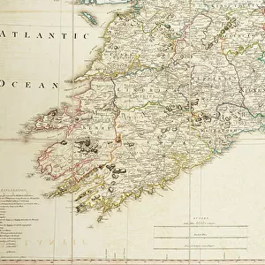
7340441 A new map of Ireland civil and ecclesiastical, 1797 (manuscript) by Beaufort, Daniel Augustus (1739-1821); 53x88 cm; National Maritime Museum, London, UK; (add.info.: Creator: Daniel A. Beaufort
By the Reverend D. A. Beaufort LLD Member of the Royal Irish Academy. This map represents only the Church of England, completely disregarding Catholic churches. See also map K0913. Dedicated to King George III. The cartouche shows cherubs with Irish produce and a cameo of George III on a quayside as a Royal Naval ship sails past. Ashore there is a church with its tower in scaffolding and a more distant Irish round tower against a backdrop of mountains.); © National Maritime Museum, Greenwich, London
Media ID 38371952
© © National Maritime Museum, Greenwich, London / Bridgeman Images
Atlantic Atlantic Ocean Ireland Irish
FEATURES IN THESE COLLECTIONS
> Architecture
> Towers
> Churches
> Europe
> Republic of Ireland
> Maps
> Europe
> United Kingdom
> England
> London
> Boroughs
> Greenwich
> Europe
> United Kingdom
> England
> London
> Museums
> Greenwich Heritage Centre
> Europe
> United Kingdom
> England
> London
> Museums
> National Maritime Museum
> Europe
> United Kingdom
> England
> London
> Royalty
> Europe
> United Kingdom
> England
> London
> Towns
> Greenwich
> Europe
> United Kingdom
> England
> Maps
> Europe
> United Kingdom
> Heritage Sites
> Maritime Greenwich
> Europe
> United Kingdom
> Maps
> Fine Art Finder
> Artists
> Daniel Augustus Beaufort
> Fine Art Finder
> Artists
> William Booth
EDITORS COMMENTS
This stunning manuscript map of Ireland, created in 1797 by the Reverend D. A. Beaufort, offers a unique glimpse into the civil and ecclesiastical landscape of the country during that time period. Measuring 53x88 cm, this intricate map is housed at the National Maritime Museum in London, UK.
What sets this map apart is its focus on the Church of England, with Catholic churches being completely disregarded. This intentional omission sheds light on the religious dynamics of Ireland in the late 18th century.
The dedication to King George III adds a regal touch to the map, with a cartouche featuring cherubs surrounded by Irish produce and a cameo of George III himself. In the background, a Royal Naval ship sails past as a church undergoes construction and an iconic Irish round tower stands tall against a mountainous backdrop.
Overall, this map not only serves as a valuable historical document but also as a work of art with its vibrant colors and detailed illustrations. It captures both the geographical features of Ireland and the religious divisions that were prevalent at that time.
MADE IN THE USA
Safe Shipping with 30 Day Money Back Guarantee
FREE PERSONALISATION*
We are proud to offer a range of customisation features including Personalised Captions, Color Filters and Picture Zoom Tools
SECURE PAYMENTS
We happily accept a wide range of payment options so you can pay for the things you need in the way that is most convenient for you
* Options may vary by product and licensing agreement. Zoomed Pictures can be adjusted in the Cart.