Home > Arts > Artists > B > William Berry
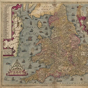
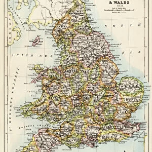
A New Map of the Kingdom of England and the Principalitie of Wales, 1669 (engraving)
")
![]()
Wall Art and Photo Gifts from Fine Art Finder
A New Map of the Kingdom of England and the Principalitie of Wales, 1669 (engraving)
XJF308735 A New Map of the Kingdom of England and the Principalitie of Wales, 1669 (engraving) by Berry, William (fl.1669); Private Collection; English, out of copyright
Media ID 12844046
© www.bridgemanart.com
Cartography Cartouche Channel Chart Geographical Mapping Navigation Principality Shipping Stuart
FEATURES IN THESE COLLECTIONS
> Arts
> Artists
> B
> William Berry
> Europe
> Republic of Ireland
> Maps
> Europe
> United Kingdom
> England
> Maps
> Europe
> United Kingdom
> Wales
> Maps
> Fine Art Finder
> Maps (celestial & Terrestrial)
> Maps and Charts
> Wales
EDITORS COMMENTS
This print showcases "A New Map of the Kingdom of England and the Principalitie of Wales, 1669" an exquisite engraving by William Berry. The map, now part of a private collection, offers a fascinating glimpse into the cartographic mastery of the time. With intricate details and precise craftsmanship, Berry's work transports us to 17th-century England and Wales. The map highlights not only the geographical features but also provides insights into navigation routes, shipping lanes, and even political boundaries. Its inclusion of Ireland further enriches our understanding of this era. The beautifully designed cartouche adds an elegant touch to the map's composition. It serves as a decorative frame for important textual information while showcasing artistic elements that were characteristic of maps from this period. As we observe this historical artifact, we are reminded of its significance in aiding exploration and trade during Stuart times. The narrow sea channel depicted on the map symbolizes both opportunities and challenges faced by seafarers navigating these waters. Through this print from Fine Art Finder at www. bridgemanart. com, we can appreciate how maps like these played a crucial role in shaping our understanding of geography and history. They serve as tangible reminders that transport us back in time while igniting curiosity about past civilizations' knowledge and achievements in mapping their world.
MADE IN THE USA
Safe Shipping with 30 Day Money Back Guarantee
FREE PERSONALISATION*
We are proud to offer a range of customisation features including Personalised Captions, Color Filters and Picture Zoom Tools
SECURE PAYMENTS
We happily accept a wide range of payment options so you can pay for the things you need in the way that is most convenient for you
* Options may vary by product and licensing agreement. Zoomed Pictures can be adjusted in the Cart.