Home > Arts > Artists > P > Peruvian School Peruvian School
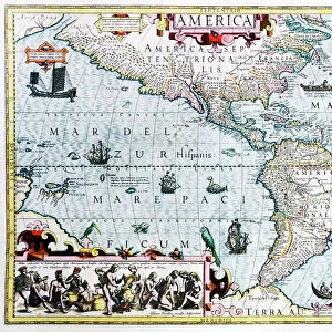
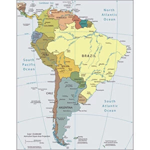
Map of Meridionale America (South America or Latin America

![]()
Wall Art and Photo Gifts from Fine Art Finder
Map of Meridionale America (South America or Latin America
GIA4805221 Map of Meridionale America (South America or Latin America) from a Spanish volume of trips from the beginning of the 17th century. The Pacific Ocean is called the South Sea and the countries of Peru and Brazil are named as well as the Equator line and the Tropic of Capricorn. by Spanish School, (17th century); Private Collection; (add.info.: Map of Meridionale America (South America or Latin America) from a Spanish volume of trips from the beginning of the 17th century. The Pacific Ocean is called the South Sea and the countries of Peru and Brazil are named as well as the Equator line and the Tropic of Capricorn.); eGiancarlo Costa; Spanish, out of copyright
Media ID 22289700
© Giancarlo Costa / Bridgeman Images
Brazil Bresilien Bresilienne Pacific Ocean Geographical Map
FEATURES IN THESE COLLECTIONS
> Arts
> Artists
> O
> Oceanic Oceanic
> Arts
> Artists
> P
> Peruvian School Peruvian School
> Arts
> Artists
> S
> Spanish School
> Europe
> Spain
> Related Images
> Fine Art Finder
> Artists
> Spanish School (after)
> Fine Art Finder
> Artists
> Unknown Artist
> Maps and Charts
> Related Images
> Maps and Charts
> Spain
> South America
> Brazil
> Maps
EDITORS COMMENTS
This print showcases a historical map titled "Map of Meridionale America (South America or Latin America)" from a Spanish volume of trips dating back to the early 17th century. The intricate details and artistic flair of this map transport us to an era when exploration was at its peak. The South Sea, known today as the Pacific Ocean, takes center stage in this ancient cartographic masterpiece. As our eyes wander across the map, we encounter the names of prominent countries like Peru and Brazil, etched elegantly onto their respective territories. The Equator line and Tropic of Capricorn also make their presence felt on this remarkable piece. Created by an unknown Spanish artist during the 17th century, this map is not only a testament to human curiosity but also serves as a window into how our understanding of geography has evolved over time. It reminds us that once upon a time, these lands were uncharted territories waiting to be discovered. Preserved within a private collection, this print captures the essence of adventure and discovery that defined an era long gone. Its rich colors and meticulous detailing offer both historians and art enthusiasts alike an opportunity to delve into South America's past while appreciating the skillful craftsmanship behind it. As we admire this rare glimpse into history through Giancarlo Costa's lens, let us appreciate how far we have come in unraveling the mysteries that lie beyond maps' borders – all while cherishing those who paved the way for our present-day knowledge.
MADE IN THE USA
Safe Shipping with 30 Day Money Back Guarantee
FREE PERSONALISATION*
We are proud to offer a range of customisation features including Personalised Captions, Color Filters and Picture Zoom Tools
FREE COLORIZATION SERVICE
You can choose advanced AI Colorization for this picture at no extra charge!
SECURE PAYMENTS
We happily accept a wide range of payment options so you can pay for the things you need in the way that is most convenient for you
* Options may vary by product and licensing agreement. Zoomed Pictures can be adjusted in the Cart.