Home > Europe > France > Paris > Maps
Map of East Africa (map of the route that Solomon fleets took) - in "
 - in '")
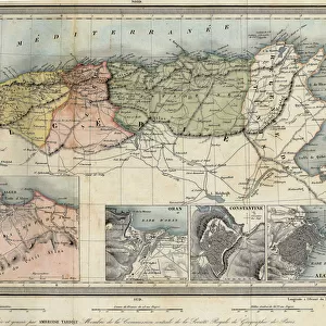
![]()
Wall Art and Photo Gifts from Fine Art Finder
Map of East Africa (map of the route that Solomon fleets took) - in "
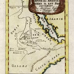
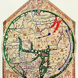
LSE4102814 Map of East Africa (map of the route that Solomon fleets took) - in " Journey to Nubia and Abyssinia undertaken to discover the sources of the Nile during the years 1768 to 1772", by James Bruce, Paris, 1790 by Bruce, James (Abyssinian Bruce) (1730-94); Jesuit Library, Cairo, Egypt; (add.info.: Map of East Africa (map of the route that Solomon fleets took) - in " Journey to Nubia and Abyssinia undertaken to discover the sources of the Nile during the years 1768 to 1772", by James Bruce, Paris, 1790); Photo eLeonard de Selva; British, out of copyright
Media ID 23697084
© Leonard de Selva / Bridgeman Images
FEATURES IN THESE COLLECTIONS
> Africa
> Ethiopia (Abyssinia)
> Maps
> Africa
> Ethiopia (Abyssinia)
> Related Images
> Africa
> Ethiopia
> Related Images
> Africa
> Related Images
> Europe
> France
> Paris
> Maps
> Fine Art Finder
> Artists
> James (1730-94) Bruce
> Fine Art Finder
> Artists
> Unknown Artist
> Maps and Charts
> Related Images
EDITORS COMMENTS
This print showcases a historical map of East Africa, specifically the route taken by Solomon fleets. The map is featured in James Bruce's renowned book "Journey to Nubia and Abyssinia undertaken to discover the sources of the Nile during the years 1768 to 1772" published in Paris in 1790. This particular edition can be found at the Jesuit Library in Cairo, Egypt. The intricate engraving on this geographical map offers a fascinating glimpse into African geography during the 18th century. It highlights key regions such as Ethiopia and Egypt, shedding light on their significance within ancient trade routes and maritime expeditions. Photographed by Leonard de Selva, this image captures not only the historical importance of Bruce's work but also serves as a visual testament to Africa's rich heritage. The detailed lines and markings on this map invite viewers to explore its complexities further. As we delve into this piece, it becomes evident that it holds more than just cartographic value; it symbolizes an era of exploration and discovery. Through Bruce's meticulous research and documentation, he sought to uncover the elusive source of the Nile River—an endeavor that captivated scholars for centuries. Incorporating elements of history, geography, and artistry, this print invites us on a journey through time—a reminder of humanity's ceaseless curiosity about our world's mysteries.
MADE IN THE USA
Safe Shipping with 30 Day Money Back Guarantee
FREE PERSONALISATION*
We are proud to offer a range of customisation features including Personalised Captions, Color Filters and Picture Zoom Tools
SECURE PAYMENTS
We happily accept a wide range of payment options so you can pay for the things you need in the way that is most convenient for you
* Options may vary by product and licensing agreement. Zoomed Pictures can be adjusted in the Cart.