Home > Europe > United Kingdom > England > London > Museums > National Maritime Museum
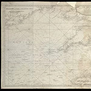
Plan of the harbour, fort, town and environs of Fort Royal in Martinique, 1793 (engraving)
")
![]()
Wall Art and Photo Gifts from Fine Art Finder
Plan of the harbour, fort, town and environs of Fort Royal in Martinique, 1793 (engraving)
7340437 Plan of the harbour, fort, town and environs of Fort Royal in Martinique, 1793 (engraving) by Booth, William (18th century); 88x70 cm; National Maritime Museum, London, UK; (add.info.: Creator: William Booth
The chart shows where the British Army and Barbados Volunteers landed in 1762 and the siege positions. In January 1762, British forces landed and besieged Fort Royal then took control of the island. It was returned to the French in the Treaty of Paris in 1763. In 1794, the year after this chart was published, the British captured Martinique again. Booth was a Lieutenant in the Royal Engineers.); © National Maritime Museum, Greenwich, London
Media ID 38371948
© © National Maritime Museum, Greenwich, London / Bridgeman Images
Boat Dock Caribbean Harbor Area Harbour Area Harbours Harbourside Martinique West Indies
FEATURES IN THESE COLLECTIONS
> Arts
> Artists
> B
> William Booth
> Europe
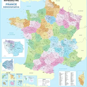
> France
> Paris
> Maps
> Europe
> United Kingdom
> England
> London
> Boroughs
> Greenwich
> Europe
> United Kingdom
> England
> London
> Museums
> British Museum
> Europe
> United Kingdom
> England
> London
> Museums
> Greenwich Heritage Centre
> Europe
> United Kingdom
> England
> London
> Museums
> National Army Museum
> Europe
> United Kingdom
> England
> London
> Museums
> National Maritime Museum
> Europe
> United Kingdom
> England
> London
> Royalty
> Europe
> United Kingdom
> England
> London
> Sights
> British Museum
> Fine Art Finder
> Artists
> Robert Sayer
> Fine Art Finder
> Artists
> William Booth
EDITORS COMMENTS
This detailed engraving captures the strategic layout of Fort Royal in Martinique in 1793, showcasing the harbor, fort, town, and surrounding environs. Created by William Booth, a Lieutenant in the Royal Engineers, this historical chart provides insight into the military tactics employed during the British capture of Martinique in 1762.
The map highlights where British forces landed and besieged Fort Royal before ultimately gaining control of the island. Despite being returned to French control in 1763 as part of the Treaty of Paris, Martinique was once again captured by the British in 1794 - just one year after this chart was published.
Booth's meticulous attention to detail is evident in every aspect of this engraving, from the color-coded cartography to the intricate depiction of fortress walls and harbor areas. The image serves as a valuable historical document that sheds light on colonial conflicts and power struggles in the Caribbean during the 18th century.
As you gaze upon this print, you can almost feel yourself transported back in time to witness firsthand the dramatic events that unfolded within these fortified walls. It's a captivating glimpse into a pivotal moment in history that forever changed the fate of Martinique.
MADE IN THE USA
Safe Shipping with 30 Day Money Back Guarantee
FREE PERSONALISATION*
We are proud to offer a range of customisation features including Personalised Captions, Color Filters and Picture Zoom Tools
SECURE PAYMENTS
We happily accept a wide range of payment options so you can pay for the things you need in the way that is most convenient for you
* Options may vary by product and licensing agreement. Zoomed Pictures can be adjusted in the Cart.