Home > Europe > United Kingdom > England > London > Museums > National Maritime Museum
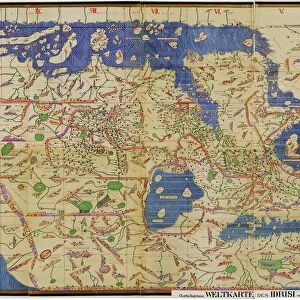
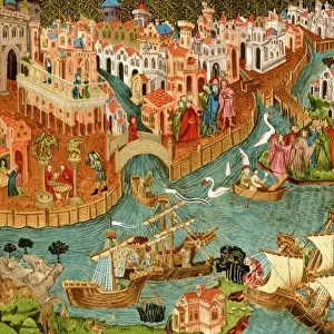
Chart of Black Sea, 1554 (vellum)
")
![]()
Wall Art and Photo Gifts from Fine Art Finder
Chart of Black Sea, 1554 (vellum)
7339645 Chart of Black Sea, 1554 (vellum) by Agnese, Battista (c.1500-64); 26x40 cm; National Maritime Museum, London, UK; (add.info.: Creator: Johan B. Agnese
'Die Tartareioda'. Scale: 1:15 000 000. Bound in an atlas made in Venice, Italy in 1554, this is one of twenty-four cartographic items titled: 'Seekarten von Battista Agnese Anno MDLIV.d.IV.May.' The text is in Latin, titles of the charts and names of the towns have been added later in German in the outside borders.
The atlas also includes astronomical tables and diagrams.); © National Maritime Museum, Greenwich, London
Media ID 38372708
© © National Maritime Museum, Greenwich, London / Bridgeman Images
FEATURES IN THESE COLLECTIONS
> Animals
> Insects
> Hemiptera
> Black Scale
> Arts
> Artists
> A
> Battista Agnese
> Europe
> Italy
> Veneto
> Venice
> Europe
> United Kingdom
> England
> London
> Boroughs
> Greenwich
> Europe
> United Kingdom
> England
> London
> Museums
> Greenwich Heritage Centre
> Europe
> United Kingdom
> England
> London
> Museums
> National Maritime Museum
> Europe
> United Kingdom
> England
> London
> Towns
> Greenwich
> Europe
> United Kingdom
> Heritage Sites
> Maritime Greenwich
> Fine Art Finder
> Artists
> Battista Agnese
> Fine Art Finder
> Artists
> Portuguese School
EDITORS COMMENTS
This stunning print captures the intricate and detailed Chart of Black Sea from 1554, created by Battista Agnese. The map, measuring 26x40 cm, is a masterpiece of cartography from the 16th century. Bound in an atlas made in Venice, Italy, this particular chart is one of twenty-four items titled 'Seekarten von Battista Agnese Anno MDLIV.d.IV.May.'
The text on the map is in Latin, with titles and town names added later in German along the outside borders. The scale of the map is an impressive 1:15,000,000. In addition to geographical details, the atlas also includes astronomical tables and diagrams.
The vibrant colors used on this vellum chart bring to life the beauty and complexity of the Black Sea region as seen through Agnese's eyes over four centuries ago. This piece serves as both a historical document and a work of art that showcases the skill and creativity of its creator.
Displayed at the National Maritime Museum in London, this print allows viewers to appreciate not only the technical expertise involved in creating such maps during that era but also provides insight into how people viewed and understood geography at that time.
MADE IN THE USA
Safe Shipping with 30 Day Money Back Guarantee
FREE PERSONALISATION*
We are proud to offer a range of customisation features including Personalised Captions, Color Filters and Picture Zoom Tools
SECURE PAYMENTS
We happily accept a wide range of payment options so you can pay for the things you need in the way that is most convenient for you
* Options may vary by product and licensing agreement. Zoomed Pictures can be adjusted in the Cart.