Home > North America > United States of America > New York > New York > Sights > New York Public Library
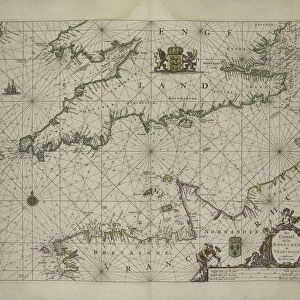
A Large Draught of the Coast of Arabia from Maculla to Dofar, 1703 (colour engraving)
")
![]()
Wall Art and Photo Gifts from Fine Art Finder
A Large Draught of the Coast of Arabia from Maculla to Dofar, 1703 (colour engraving)
5242478 A Large Draught of the Coast of Arabia from Maculla to Dofar, 1703 (colour engraving) by Nicholls, Sutton (fl.1700-40); New York Public Library, USA; (add.info.: by Sam Thornton
Sea chart of the coast of Yemen and Oman from the celebrated Third Book of The English Pilot ); English, out of copyright
Media ID 22567266
© Bridgeman Images
Arabia Arabian Arabian Sea Atlas Cartography Compass Desert Hydrography Nautical Navigation Oman Rhumb Lines Sea Chart Thornton Yemen Dhofar
FEATURES IN THESE COLLECTIONS
> Arts
> Artists
> G
> Pieter Goos
> Arts
> Artists
> N
> Sutton Nicholls
> Fine Art Finder
> Artists
> Pieter Goos
> Fine Art Finder
> Artists
> Sutton Nicholls
> Maps and Charts
> Related Images
> North America
> United States of America
> Maps
> North America
> United States of America
> New York
> New York
> Maps
> North America
> United States of America
> New York
> New York
> Sights
> New York Public Library
EDITORS COMMENTS
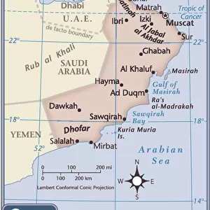
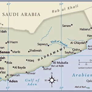
This vibrant and detailed print captures "A Large Draught of the Coast of Arabia from Maculla to Dofar" in 1703. Created by Nicholls, Sutton, this colour engraving showcases the remarkable craftsmanship and artistry of Sam Thornton. Housed at the New York Public Library, USA, this historical sea chart offers a fascinating glimpse into cartography and hydrography during that era. The image depicts the coastal regions of Yemen and Oman along the Arabian Sea. With its intricate rhumb lines and compass markings, this maritime map served as an essential tool for navigation in those times. The engraving beautifully portrays the vastness of the ocean while highlighting key landmarks such as Dhofar and Al Makullah. As you delve into this artwork's finer details, you'll be captivated by its portrayal of both desert landscapes and stunning coastlines. This print not only serves as a testament to Thornton's skill but also provides valuable insights into Arabian geography centuries ago. Whether you are a lover of history or simply appreciate fine art, this enchanting print is sure to transport you back in time. Its rich colors and meticulous engravings make it an exquisite addition to any collection or display dedicated to exploration or maritime heritage.
MADE IN THE USA
Safe Shipping with 30 Day Money Back Guarantee
FREE PERSONALISATION*
We are proud to offer a range of customisation features including Personalised Captions, Color Filters and Picture Zoom Tools
SECURE PAYMENTS
We happily accept a wide range of payment options so you can pay for the things you need in the way that is most convenient for you
* Options may vary by product and licensing agreement. Zoomed Pictures can be adjusted in the Cart.