Home > Europe > United Kingdom > Scotland > Edinburgh > Edinburgh
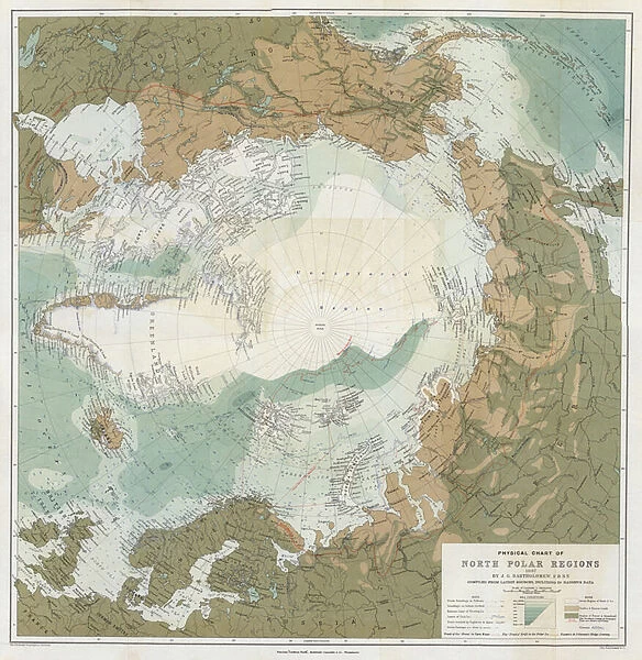
Physical chart of the North Polar Regions (colour litho)
![]()

Wall Art and Photo Gifts from Fine Art Finder
Physical chart of the North Polar Regions (colour litho)
820163 Physical chart of the North Polar Regions (colour litho) by English School, (19th century); Private Collection; (add.info.: Physical chart of the North Polar Regions, by John George Bartholomew, 1897, compiled from the latest sources, including Dr Nansens data. For the Edinburgh Geographical Institute, published by John Bartholomew & Co.); Look and Learn / Elgar Collection; English, out of copyright
Media ID 23503376
© Look and Learn / Elgar Collection / Bridgeman Images
Caps Chart Fram Fridtjof Nansen North Pole Physical Polar Regions Edinburgh Geographical Institute
FEATURES IN THESE COLLECTIONS
> Europe
> United Kingdom
> Scotland
> Edinburgh
> Edinburgh
> Europe
> United Kingdom
> Scotland
> Lothian
> Edinburgh
> Fine Art Finder
> Artists
> English School
> Fine Art Finder
> Artists
> Peter (after) Lely
> Fine Art Finder
> Temp Classification
> Maps and Charts
> Related Images
EDITORS COMMENTS
This print showcases a remarkable piece of cartography from the 19th century - the "Physical chart of the North Polar Regions". Created by John George Bartholomew in 1897, this colourful lithograph is a testament to both scientific exploration and artistic craftsmanship. The chart, compiled from the latest sources including data from renowned explorer Dr Nansen, offers an intricate depiction of the polar regions. It provides a comprehensive understanding of the geography and physical features found in these remote and inhospitable areas. As we gaze upon this historical treasure, we are transported back to a time when expeditions to the North Pole were filled with mystery and danger. The iconic ship Fram, used by explorers like Fridtjof Nansen during their ambitious quests for discovery, can be seen navigating through treacherous icy waters on this detailed map. With its meticulous attention to detail and accurate representation of topographical features, this chart serves as both an educational tool and a work of art. Its presence in private collections speaks volumes about its significance within cartographic history. Let us marvel at this extraordinary snapshot frozen in time; it reminds us not only of our fascination with exploration but also highlights humanity's relentless pursuit to unravel nature's secrets hidden within these enigmatic polar realms.
MADE IN THE USA
Safe Shipping with 30 Day Money Back Guarantee
FREE PERSONALISATION*
We are proud to offer a range of customisation features including Personalised Captions, Color Filters and Picture Zoom Tools
SECURE PAYMENTS
We happily accept a wide range of payment options so you can pay for the things you need in the way that is most convenient for you
* Options may vary by product and licensing agreement. Zoomed Pictures can be adjusted in the Cart.


