Home > Europe > United Kingdom > England > London > Museums > National Maritime Museum
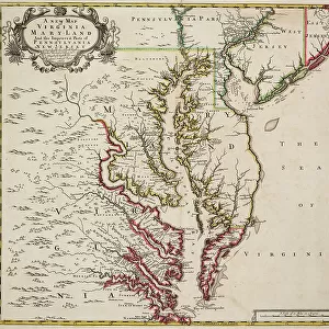
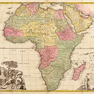
Map of Virginia, 1719 (engraving)
")
![]()
Wall Art and Photo Gifts from Fine Art Finder
Map of Virginia, 1719 (engraving)
7339511 Map of Virginia, 1719 (engraving) by Senex, John (1678-1740); 49x56 cm; National Maritime Museum, London, UK; (add.info.: Creator: John Senex
Scale: 1:1 000 000 in miles. A chart showing the North America Atlantic Coast The borders are graduated for latitude and longitude, (London meridian). Inscribed 'A new map of Virginia Maryland and the improved parts of Pennsylvania & New-Jersey. Most humbly inscribed to the Right Honourable the Earl of Orkney Knight of ye most noble and ancient Order of ye Thistle 1719. Revised by I. Senex'.); © National Maritime Museum, Greenwich, London
Media ID 38339668
© © National Maritime Museum, Greenwich, London / Bridgeman Images
Atlantic Atlantic Ocean Viginia Virginia
FEATURES IN THESE COLLECTIONS
> Animals
> Mammals
> Sciuridae
> Senex
> Arts
> Artists
> S
> John Senex
> Europe
> United Kingdom
> England
> London
> Boroughs
> Greenwich
> Europe
> United Kingdom
> England
> London
> Museums
> Greenwich Heritage Centre
> Europe
> United Kingdom
> England
> London
> Museums
> National Maritime Museum
> Europe
> United Kingdom
> England
> London
> Towns
> Greenwich
> Europe
> United Kingdom
> Heritage Sites
> Maritime Greenwich
> Europe
> United Kingdom
> Maps
> Europe
> United Kingdom
> Scotland
> Orkney
> Fine Art Finder
> Artists
> John Senex
> Fine Art Finder
> Artists
> Joseph Smith Speer
EDITORS COMMENTS
This stunning engraving of the Map of Virginia from 1719 by John Senex is a true masterpiece of cartography. The intricate details and vibrant colors bring to life the early colonial era in America, showcasing the borders of Virginia, Maryland, Pennsylvania, and New Jersey. The map is inscribed with dedication to the Earl of Orkney, adding a touch of historical significance to this piece.
The scale of 1:1,000,000 in miles allows for a detailed look at the North American Atlantic Coast, with latitude and longitude lines graduated along the London meridian. This map serves as a valuable historical document, providing insight into how these regions were perceived and mapped during the 18th century.
As we gaze upon this print from the National Maritime Museum in London, we are transported back in time to an era when exploration and colonization were shaping the landscape of America. The attention to detail and precision in mapping make this engraving not only visually captivating but also historically significant.
Whether you are a lover of history or simply appreciate fine artistry, this Map of Virginia from 1719 is sure to captivate your imagination and transport you to another time.
MADE IN THE USA
Safe Shipping with 30 Day Money Back Guarantee
FREE PERSONALISATION*
We are proud to offer a range of customisation features including Personalised Captions, Color Filters and Picture Zoom Tools
SECURE PAYMENTS
We happily accept a wide range of payment options so you can pay for the things you need in the way that is most convenient for you
* Options may vary by product and licensing agreement. Zoomed Pictures can be adjusted in the Cart.