Home > Europe > United Kingdom > England > London > Museums > National Maritime Museum
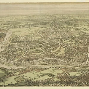
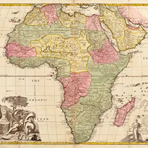
A plan of the city and harbour of Louisburg, Cape Breton, 1750 (engraving)
")
![]()
Wall Art and Photo Gifts from Fine Art Finder
A plan of the city and harbour of Louisburg, Cape Breton, 1750 (engraving)
7339513 A plan of the city and harbour of Louisburg, Cape Breton, 1750 (engraving) by Hinton, J. (18th century); 27x37 cm; National Maritime Museum, London, UK; (add.info.: Creator: J. Hinton
With the French batteries that defended it, and those of the English, shewing that part of Garbarus Bay in which they landed & the ground on which they encamped during the siege in 1745. The French built the fortress of Louisburg 1720-1740. The action in 1745 was to stop French privateers from Gabarus Bay preying on New England Grand Banks fishermen. The 1748 Treaty of Aix la Chapelle returned the fortress to the French in exchange for Madras.); © National Maritime Museum, Greenwich, London
Media ID 38339672
© © National Maritime Museum, Greenwich, London / Bridgeman Images
Boat Dock Harbor Area Harbour Area Harbours Port Area Canadians
FEATURES IN THESE COLLECTIONS
> Europe
> United Kingdom
> England
> London
> Boroughs
> Greenwich
> Europe
> United Kingdom
> England
> London
> Museums
> Greenwich Heritage Centre
> Europe
> United Kingdom
> England
> London
> Museums
> National Maritime Museum
> Europe
> United Kingdom
> England
> London
> Towns
> Greenwich
> Europe
> United Kingdom
> England
> Maps
> Europe
> United Kingdom
> Heritage Sites
> Maritime Greenwich
> Europe
> United Kingdom
> Maps
> Fine Art Finder
> Artists
> John Senex
> Maps and Charts
> Early Maps
EDITORS COMMENTS
This engraving from 1750 showcases a detailed plan of the city and harbour of Louisburg, Cape Breton. Created by J. Hinton in the 18th century, this historical piece provides a glimpse into the layout of the French fortress and English batteries that defended it during the siege in 1745.
The strategic importance of Louisburg is evident as it served as a stronghold for French privateers preying on New England Grand Banks fishermen. The action taken to seize control of Louisburg in 1745 was crucial in maintaining peace and security in the region.
The intricate details captured in this engraving offer a unique perspective on the geography and architecture of Louisburg at that time. From the layout of Garbarus Bay to the ground where English forces encamped during the siege, every aspect is meticulously depicted.
As we admire this piece from National Maritime Museum, London, we are transported back to a pivotal moment in history when nations vied for control over key territories. The exchange between France and England following the Treaty of Aix la Chapelle underscores the significance of Louisburg as a bargaining chip in international diplomacy.
Overall, this print serves as both an artistic masterpiece and a valuable historical document shedding light on colonial rivalries and military strategies in North America during the 18th century.
MADE IN THE USA
Safe Shipping with 30 Day Money Back Guarantee
FREE PERSONALISATION*
We are proud to offer a range of customisation features including Personalised Captions, Color Filters and Picture Zoom Tools
SECURE PAYMENTS
We happily accept a wide range of payment options so you can pay for the things you need in the way that is most convenient for you
* Options may vary by product and licensing agreement. Zoomed Pictures can be adjusted in the Cart.