Home > North America > United States of America > New York > New York > Maps
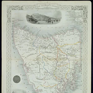
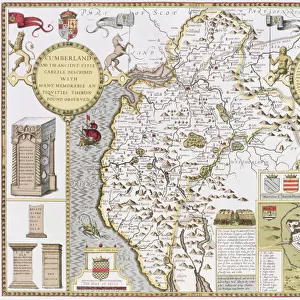
Part of South Australia, from a Series of World Maps published by John Tallis & Co

![]()
Wall Art and Photo Gifts from Fine Art Finder
Part of South Australia, from a Series of World Maps published by John Tallis & Co
STC190604 Part of South Australia, from a Series of World Maps published by John Tallis & Co, New York & London, 1850s (engraving) by Rapkin, John (fl.1839-77); Private Collection; (add.info.: vignette illustrations by H. Warren, engraved by J. Rogers; ); The Stapleton Collection; British, out of copyright
Media ID 22931218
© The Stapleton Collection / Bridgeman Images
Aboriginal Aborigine Adelaide Dingo Kangaroo Island Spencer Gulf
FEATURES IN THESE COLLECTIONS
> Arts
> Artists
> R
> John Rapkin
> Arts
> Artists
> R
> John Rogers
> Arts
> Artists
> T
> John Tallis
> Fine Art Finder
> Artists
> John Rapkin
> Fine Art Finder
> Maps (celestial & Terrestrial)
> Maps and Charts
> Related Images
> Maps and Charts
> World
> North America
> United States of America
> New York
> New York
> Maps
> North America
> United States of America
> New York
> Related Images
> Oceania
> Australia
> Adelaide
EDITORS COMMENTS
This print showcases a mesmerizing part of South Australia, taken from a remarkable series of world maps published by John Tallis & Co in the 1850s. The engraving, skillfully crafted by John Rapkin, offers an intricate depiction of this Australian region's diverse landscape and cultural heritage. As we delve into the image, our eyes are immediately drawn to the majestic Spencer Gulf stretching out before us. Its tranquil waters provide a serene backdrop for the scene that unfolds within it. A group of indigenous people gracefully navigate their catamaran through these pristine waters, showcasing their ancient seafaring traditions. The presence of an Australian dog further emphasizes the rich biodiversity found in this part of South Australia. Kangaroo Island looms majestically in the distance, its untouched beauty beckoning explorers and nature enthusiasts alike. The map itself is adorned with vignette illustrations by H. Warren and engraved by J. Rogers, adding an artistic touch to this historical document. Mining districts are carefully marked on the map, highlighting the importance of this industry during that era. Intriguingly, we catch glimpses of native wildlife such as kangaroos and dingoes roaming freely across this vast land. These creatures serve as reminders of Australia's unique fauna that has captivated naturalists for centuries. Overall, this print encapsulates not only a geographical representation but also provides insight into South Australia's indigenous culture and natural wonders—a testament to its timeless allure captured beautifully by Bridgeman Images'
MADE IN THE USA
Safe Shipping with 30 Day Money Back Guarantee
FREE PERSONALISATION*
We are proud to offer a range of customisation features including Personalised Captions, Color Filters and Picture Zoom Tools
SECURE PAYMENTS
We happily accept a wide range of payment options so you can pay for the things you need in the way that is most convenient for you
* Options may vary by product and licensing agreement. Zoomed Pictures can be adjusted in the Cart.