Home > Europe > United Kingdom > England > London > Museums > National Maritime Museum
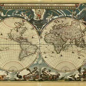
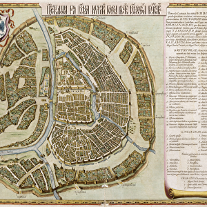
Map of Europe from the Blaeu Atlas, 17th century, 1622-25 (print)
")
![]()
Wall Art and Photo Gifts from Fine Art Finder
Map of Europe from the Blaeu Atlas, 17th century, 1622-25 (print)
7339183 Map of Europe from the Blaeu Atlas, 17th century, 1622-25 (print) by Blaeu, Joan (1596-1673); National Maritime Museum, London, UK; (add.info.: Creator: John Blaeu
Map of Europe from the Bleau Atlas. John (or Joan) Blaeu (1596-1673) was a Dutch printer, son of map maker Willem Janszoon Blaeu.); © National Maritime Museum, Greenwich, London
Media ID 38176534
© © National Maritime Museum, Greenwich, London / Bridgeman Images
FEATURES IN THESE COLLECTIONS
> Arts
> Artists
> B
> Joan Blaeu
> Arts
> Artists
> B
> Willem Blaeu
> Europe
> United Kingdom
> England
> London
> Boroughs
> Greenwich
> Europe
> United Kingdom
> England
> London
> Museums
> Greenwich Heritage Centre
> Europe
> United Kingdom
> England
> London
> Museums
> National Maritime Museum
> Europe
> United Kingdom
> England
> London
> Towns
> Greenwich
> Europe
> United Kingdom
> Heritage Sites
> Maritime Greenwich
> Europe
> United Kingdom
> Maps
> Fine Art Finder
> Artists
> Joan Blaeu
> Maps and Charts
> Early Maps
EDITORS COMMENTS
This stunning print of a Map of Europe from the Blaeu Atlas, dating back to the 17th century, is a true masterpiece of cartography. Created by Dutch printer John Blaeu, this intricate map showcases the European continent in exquisite detail.
The vibrant colors and meticulous attention to detail make this map a work of art in its own right. From the rolling hills of France to the rugged coastlines of Scandinavia, every corner of Europe is beautifully rendered on this historic print.
As you study this map, you can't help but marvel at the skill and precision that went into its creation. Each city, river, and mountain range is carefully labeled and depicted with remarkable accuracy.
In an era long before GPS or satellite imagery, maps like these were essential tools for explorers and navigators seeking to chart new territories. The Blaeu Atlas was renowned for its quality and craftsmanship, making it a valuable resource for scholars and adventurers alike.
Whether you're a history buff or simply appreciate fine art, this Map of Europe from the 17th century is sure to captivate your imagination. It's not just a map - it's a window into another time and place, inviting you to explore the world as it was centuries ago.
MADE IN THE USA
Safe Shipping with 30 Day Money Back Guarantee
FREE PERSONALISATION*
We are proud to offer a range of customisation features including Personalised Captions, Color Filters and Picture Zoom Tools
SECURE PAYMENTS
We happily accept a wide range of payment options so you can pay for the things you need in the way that is most convenient for you
* Options may vary by product and licensing agreement. Zoomed Pictures can be adjusted in the Cart.