Home > Animals > Mammals > Muridae > Western Mouse
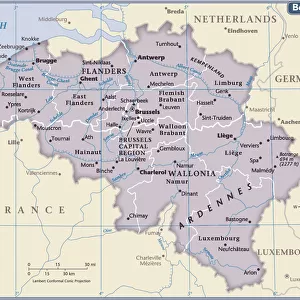
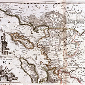
Map of the County of Flanders (present-day Western and Eastern Flanders of Belgium

![]()
Wall Art and Photo Gifts from Fine Art Finder
Map of the County of Flanders (present-day Western and Eastern Flanders of Belgium
LRI4712254 Map of the County of Flanders (present-day Western and Eastern Flanders of Belgium) (Engraving, 1717) by Nolin, Jean-Baptiste (c.1657-1708); Private Collection; (add.info.: Map of the Count of Flanders (present-day Western and Eastern Flanders of Belgium) - Engraving from the atlas le theatre du monde, 1717, by Jean Baptiste Nolin (1686-1762) - Map of Eastern and Western Flanders of Belgium - From " Le Theatre du Monde" 1717 by Jean-Baptiste Nolin); Luisa Ricciarini; French, out of copyright
Media ID 22278874
© Luisa Ricciarini / Bridgeman Images
Atlas Book Flemish Region Geographical Map
FEATURES IN THESE COLLECTIONS
> Animals
> Mammals
> Muridae
> Western Mouse
> Europe
> Belgium
> Related Images
> Fine Art Finder
> Artists
> Jean-Baptiste Nolin
> Maps and Charts
> Related Images
EDITORS COMMENTS
This print showcases a historical treasure, the "Map of the County of Flanders" by Jean-Baptiste Nolin. Created in 1717, this engraving offers a glimpse into the rich geography and intricate details of present-day Western and Eastern Flanders in Belgium. Nolin's masterful craftsmanship is evident as he meticulously depicts the Flemish region with precision and artistry. The map is part of his renowned atlas, "Le Theatre du Monde" which solidified his reputation as a distinguished cartographer. As we delve into this remarkable piece, we are transported back to the 18th century, where every line and contour tells a story. This map was not only an essential navigational tool but also an exquisite work of art that showcased Nolin's expertise. The beauty lies not only in its accuracy but also in its ability to evoke curiosity about the past. It invites us to explore forgotten landscapes and rediscover centuries-old towns and cities that have shaped Flanders' history. Luisa Ricciarini has skillfully captured this significant artifact through her lens, preserving it for future generations to admire. Her dedication to showcasing fine art allows us all to appreciate these cultural gems from around the world. This print serves as a reminder of our shared heritage and encourages us to embrace our roots while celebrating diversity. Let it inspire you to embark on your own journey through time as you immerse yourself in the enchanting land depicted on this extraordinary map.
MADE IN THE USA
Safe Shipping with 30 Day Money Back Guarantee
FREE PERSONALISATION*
We are proud to offer a range of customisation features including Personalised Captions, Color Filters and Picture Zoom Tools
SECURE PAYMENTS
We happily accept a wide range of payment options so you can pay for the things you need in the way that is most convenient for you
* Options may vary by product and licensing agreement. Zoomed Pictures can be adjusted in the Cart.