Home > Europe > United Kingdom > England > London > Museums > National Maritime Museum
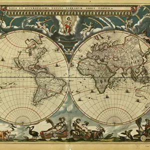
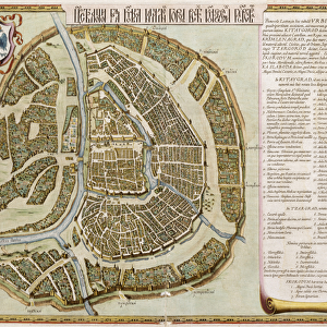
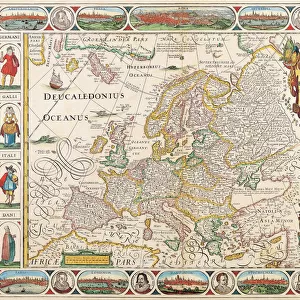
World map from the Blaeu Atlas, 17th century, c.1662 (print)
")
![]()
Wall Art and Photo Gifts from Fine Art Finder
World map from the Blaeu Atlas, 17th century, c.1662 (print)
7339181 World map from the Blaeu Atlas, 17th century, c.1662 (print) by Blaeu, Joan (1596-1673); National Maritime Museum, London, UK; (add.info.: Creator: John Blaeu
World map from Bleau Atlas, around 1662. John (or Joan) Blaeu (1596-1673) was a Dutch printer, son of map maker Willem Janszoon Blaeu.); © National Maritime Museum, Greenwich, London
Media ID 38176532
© © National Maritime Museum, Greenwich, London / Bridgeman Images
Atlas (book Of Maps) World Map
FEATURES IN THESE COLLECTIONS
> Arts
> Artists
> B
> Joan Blaeu
> Arts
> Artists
> B
> Willem Blaeu
> Europe
> United Kingdom
> England
> London
> Boroughs
> Greenwich
> Europe
> United Kingdom
> England
> London
> Museums
> Greenwich Heritage Centre
> Europe
> United Kingdom
> England
> London
> Museums
> National Maritime Museum
> Europe
> United Kingdom
> England
> London
> Towns
> Greenwich
> Europe
> United Kingdom
> Heritage Sites
> Maritime Greenwich
> Europe
> United Kingdom
> Maps
> Fine Art Finder
> Artists
> Jan Wyck
> Fine Art Finder
> Artists
> Joan Blaeu
> Maps and Charts
> Early Maps
> Maps and Charts
> World
EDITORS COMMENTS
This stunning print of a World map from the Blaeu Atlas, dating back to the 17th century, is a true masterpiece of cartography. Created by John Blaeu around 1662, this intricate and detailed map showcases the vast expanse of the known world during that time.
John Blaeu, a Dutch printer and son of renowned map maker Willem Janszoon Blaeu, was known for his exceptional skill in creating maps that were not only accurate but also visually captivating. The vibrant colors used in this particular map bring to life different regions and territories, making it both informative and aesthetically pleasing.
As you gaze upon this historic piece, you can't help but marvel at the level of detail put into every inch of the map. From coastlines to mountain ranges, each element is meticulously drawn with precision and care. It serves as a reminder of how far we have come in terms of exploration and understanding our world.
Displayed at the National Maritime Museum in London, this print is not just a representation of geographical knowledge but also a work of art that stands the test of time. It's a window into history that allows us to appreciate the craftsmanship and dedication that went into creating such an important document.
MADE IN THE USA
Safe Shipping with 30 Day Money Back Guarantee
FREE PERSONALISATION*
We are proud to offer a range of customisation features including Personalised Captions, Color Filters and Picture Zoom Tools
SECURE PAYMENTS
We happily accept a wide range of payment options so you can pay for the things you need in the way that is most convenient for you
* Options may vary by product and licensing agreement. Zoomed Pictures can be adjusted in the Cart.