Home > Europe > France > Canton > Gard
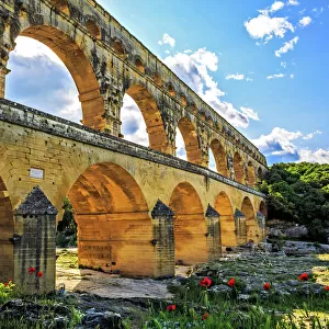
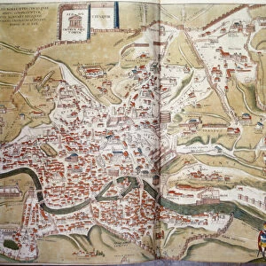
View of Rouen (Rotomagus), Nimes (Nemausus) and Bordeaux (Burdigala), France (etching
, Nimes (Nemausus) and Bordeaux (Burdigala), France (etching")
![]()
Wall Art and Photo Gifts from Fine Art Finder
View of Rouen (Rotomagus), Nimes (Nemausus) and Bordeaux (Burdigala), France (etching
LRI4707261 View of Rouen (Rotomagus), Nimes (Nemausus) and Bordeaux (Burdigala), France (etching, 1572-1617) by Hogenberg, Franz (1540-c.1590); Private Collection; (add.info.: Vues de Rouen (Rotomagus), Nimes (Nemausus) and Bordeaux (Burdigala), France - Water forte extracted by Civitates Orbis Terrarum (Atlas of the cities of the world) by Georg Braun (1541-1622) and Franz Hogenberg (1540-1590), published from 1572 to 1617 - Rouen, Nimes and Bordeaux, France - From " Civates Bis Terrarum" by G. Braun and F. Hogenberg, 1572-1617); Luisa Ricciarini; Netherlandish, out of copyright
Media ID 23718170
© Luisa Ricciarini / Bridgeman Images
Aquitaine Atlas Book Gard 30 Geographical Map Gironde 33 Haute Normandy Languedoc Roussillon Seine Maritime 76 Exterior View Normandy
FEATURES IN THESE COLLECTIONS
> Arts
> Artists
> H
> Franz Hogenberg
> Europe
> France
> Canton
> Gard
> Europe
> France
> Canton
> Gironde
> Europe
> France
> Canton
> Seine
> Fine Art Finder
> Artists
> Franz Hogenberg
> Maps and Charts
> Related Images
EDITORS COMMENTS
This print titled "View of Rouen (Rotomagus), Nimes (Nemausus) and Bordeaux (Burdigala), France" takes us on a journey through time to explore the beauty and grandeur of three iconic French cities. Created by Hogenberg, Franz in the late 16th century, this etching showcases his exceptional talent for capturing architectural details and cityscapes. The image transports us to Rouen, Nimes, and Bordeaux, allowing us to marvel at their unique charm. From the picturesque streets of Rouen with its stunning cathedral towering over the cityscape, to Nimes' ancient Roman ruins that still stand proudly today, each city offers a glimpse into its rich history. The intricate lines and delicate shading in this engraving bring these cities to life before our eyes. We can almost feel the hustle and bustle of daily life as we imagine people going about their business in these vibrant urban centers. Published as part of Civitates Orbis Terrarum by Georg Braun and Franz Hogenberg between 1572-1617, this artwork is not only visually striking but also holds historical significance as an important geographical map. It provides valuable insights into the layout and development of these regions during that era. Luisa Ricciarini's skillful reproduction ensures that this remarkable piece continues to captivate viewers even centuries later. Whether you are a lover of art or have an interest in French history or geography, this print is sure to
MADE IN THE USA
Safe Shipping with 30 Day Money Back Guarantee
FREE PERSONALISATION*
We are proud to offer a range of customisation features including Personalised Captions, Color Filters and Picture Zoom Tools
SECURE PAYMENTS
We happily accept a wide range of payment options so you can pay for the things you need in the way that is most convenient for you
* Options may vary by product and licensing agreement. Zoomed Pictures can be adjusted in the Cart.