Home > Arts > Artists > H > Franz Hogenberg
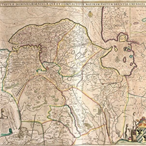
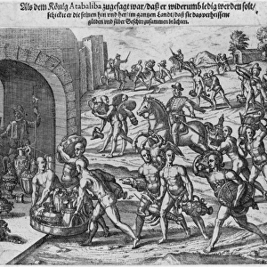
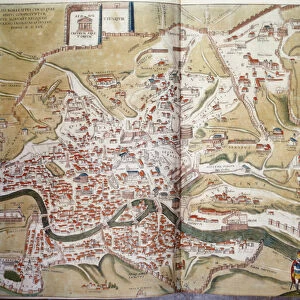
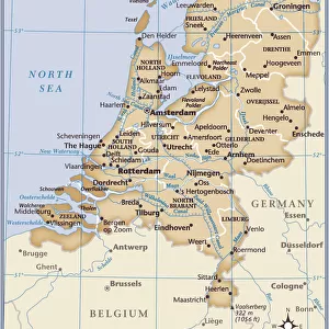
Plan of Groningen (Groninga), Netherlands (etching, 1572-1617)
, Netherlands (etching, 1572-1617)")
![]()
Wall Art and Photo Gifts from Fine Art Finder
Plan of Groningen (Groninga), Netherlands (etching, 1572-1617)
LRI4709172 Plan of Groningen (Groninga), Netherlands (etching, 1572-1617) by Hogenberg, Franz (1540-c.1590); Private Collection; (add.info.: Plan of Groningen (Groninga), Netherlands - Strong water extracted from Civitates Orbis Terrarum (Atlas of World Cities) by Georg Braun (1541-1622) and Franz Hogenberg (1540-1590), published from 1572 to 1617 - Groningen, Netherlands - From " Civitates Orbis Terrarum" by G. Braun and F. Hogenberg, 1572-1617); Luisa Ricciarini; Netherlandish, out of copyright
Media ID 22278562
© Luisa Ricciarini / Bridgeman Images
Atlas Book Blazon Canal Coat Of Arm Neerlanders Stronghold Exterior View Geographical Map
FEATURES IN THESE COLLECTIONS
> Animals
> Mammals
> Muridae
> Water Mouse
> Arts
> Artists
> H
> Franz Hogenberg
> Europe
> Netherlands
> Groningen
> Europe
> Netherlands
> Maps
> Europe
> Netherlands
> Posters
> Europe
> Netherlands
> Related Images
> Fine Art Finder
> Artists
> Franz Hogenberg
> Maps and Charts
> Netherlands
> Maps and Charts
> Related Images
> Maps and Charts
> World
> Religious Art
> Religious Architecture
> Churches and Cathedrals
EDITORS COMMENTS
This print showcases the intricate and detailed "Plan of Groningen" by Franz Hogenberg, a renowned Netherlandish artist from the 16th century. The etching, created between 1572 and 1617, offers a fascinating glimpse into the historical city of Groningen in the Netherlands. The plan depicts an exterior view of Groningen, highlighting its architectural marvels such as churches, buildings, and fortifications. With its strong water extracted from Civitates Orbis Terrarum (Atlas of World Cities) by Georg Braun and Franz Hogenberg, this map provides valuable insights into the geography and layout of Groningen during that time period. The image also captures elements of daily life in Groningen with fields stretching out beyond the city walls. Canals meander through the landscape, showcasing both agricultural activities and transportation routes that were vital to the region's prosperity. Notably present are blazons or coats of arms representing different factions within Groningen society. These symbols serve as reminders of power dynamics prevalent during that era. Luisa Ricciarini skillfully brings this historical artwork to life through her expert engraving technique. Her attention to detail allows viewers to immerse themselves in this rich tapestry depicting one corner of Dutch history. This print is part of Luisa Ricciarini's collection featuring maps from Braun and Hogenberg's "Civitates Orbis Terrarum" offering art enthusiasts an opportunity to explore cities around the world through
MADE IN THE USA
Safe Shipping with 30 Day Money Back Guarantee
FREE PERSONALISATION*
We are proud to offer a range of customisation features including Personalised Captions, Color Filters and Picture Zoom Tools
SECURE PAYMENTS
We happily accept a wide range of payment options so you can pay for the things you need in the way that is most convenient for you
* Options may vary by product and licensing agreement. Zoomed Pictures can be adjusted in the Cart.