Home > Europe > Denmark > Maps
Map of North America (Greenland, Canada, USA, Mexico and the Caribbean Islands: Cuba

![]()
Wall Art and Photo Gifts from Fine Art Finder
Map of North America (Greenland, Canada, USA, Mexico and the Caribbean Islands: Cuba
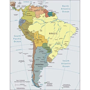
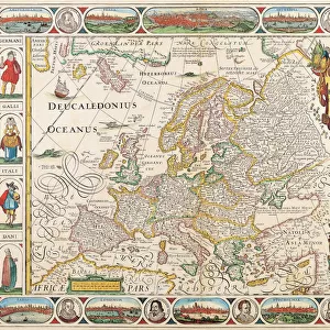
LRI4706891 Map of North America (Greenland, Canada, USA, Mexico and the Caribbean Islands: Cuba, Haiti, Jamaica, West Indies) (etching, 1730) by Delisle, Guillaume (1675-1726); Private Collection; (add.info.: Map of North America (Greenland, Canada, USA, Mexico and the Caribbean Islands: Cuba, Haiti, Jamaica, West Indies) - Strong water extracted from the " New Atlas containing all parts of the world" 1730 by Guillaume de L Isle (1675-1726)); Luisa Ricciarini; French, out of copyright
Media ID 23718162
© Luisa Ricciarini / Bridgeman Images
Atlas Book Caribbean Central America Cuba Cuban Danish Danish Women Denmark Geographical Map Greenland Haiti Jamaica Jamaican Mexican Mexico Nordic Countries America Continent Canadians
FEATURES IN THESE COLLECTIONS
> Europe
> Denmark
> Related Images
> Europe
> United Kingdom
> Scotland
> Western Isles
> Related Images
> Fine Art Finder
> Artists
> Franz Hogenberg
> Fine Art Finder
> Artists
> Guillaume Delisle
> Maps and Charts
> Related Images
> Maps and Charts
> World
EDITORS COMMENTS
This print showcases a remarkable historical artifact - the "Map of North America (Greenland, Canada, USA, Mexico and the Caribbean Islands: Cuba, Haiti, Jamaica, West Indies)" by Guillaume de L'Isle. Created in 1730 and extracted from the renowned "New Atlas containing all parts of the world" this etching offers a glimpse into the geographical understanding of that era. The map encompasses an extensive area spanning Greenland to Mexico and includes notable countries like Canada, USA, Cuba, Haiti, Jamaica, and various islands within the West Indies. Its intricate details provide valuable insights into the geography of North America during the 18th century. Guillaume de L'Isle's expertise as a cartographer is evident in this masterpiece. The precision with which he delineates coastlines and accurately positions each country demonstrates his commitment to accuracy in mapping. This particular print has been preserved in a private collection for generations. Luisa Ricciarini expertly captures this historical treasure through her lens. Her careful attention to detail allows viewers to appreciate not only the artistic beauty but also its educational significance. As we gaze upon this image today, we are transported back in time to an era when exploration was at its peak and our understanding of North America was expanding rapidly. This photograph serves as a reminder of how far we have come in terms of geographic knowledge while honoring those who paved the way for our current understanding of these lands.
MADE IN THE USA
Safe Shipping with 30 Day Money Back Guarantee
FREE PERSONALISATION*
We are proud to offer a range of customisation features including Personalised Captions, Color Filters and Picture Zoom Tools
SECURE PAYMENTS
We happily accept a wide range of payment options so you can pay for the things you need in the way that is most convenient for you
* Options may vary by product and licensing agreement. Zoomed Pictures can be adjusted in the Cart.