Home > Africa > Ethiopia (Abyssinia) > Maps
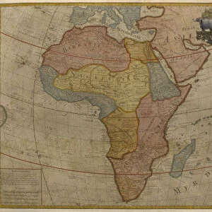
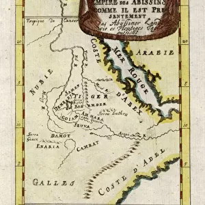
Map of Egypt, Nubia (Sudan) and Abyssinia (Ethiopia) (etching, 1730)
 and Abyssinia (Ethiopia) (etching, 1730)")
![]()
Wall Art and Photo Gifts from Fine Art Finder
Map of Egypt, Nubia (Sudan) and Abyssinia (Ethiopia) (etching, 1730)
LRI4706896 Map of Egypt, Nubia (Sudan) and Abyssinia (Ethiopia) (etching, 1730) by Delisle, Guillaume (1675-1726); Private Collection; (add.info.: Map of Egypt, Nubia (Sudan) and Abyssinia (Ethiopia) - Strong water extracted from the " New Atlas containing all parts of the world" 1730 by Guillaume de L Isle (1675-1726)); Luisa Ricciarini; French, out of copyright
Media ID 22467758
© Luisa Ricciarini / Bridgeman Images
Atlas Book Ethiopia Geographical Map Sudan
FEATURES IN THESE COLLECTIONS
> Africa
> Egypt
> Related Images
> Africa
> Ethiopia (Abyssinia)
> Maps
> Africa
> Ethiopia (Abyssinia)
> Related Images
> Africa
> Ethiopia
> Related Images
> Africa
> Related Images
> Africa
> Sudan
> Related Images
> Fine Art Finder
> Artists
> Franz Hogenberg
> Fine Art Finder
> Artists
> Guillaume Delisle
EDITORS COMMENTS
This etching from 1730, titled "Map of Egypt, Nubia (Sudan) and Abyssinia (Ethiopia)" takes us on a journey through the rich history and geography of Africa. Created by Guillaume de L'Isle, a renowned French cartographer, this print is an extract from his esteemed work "New Atlas containing all parts of the world". The intricate details and precision in this map showcase de L'Isle's mastery in cartography. The viewer is transported to ancient times as they explore the lands of Egypt, Nubia (Sudan), and Abyssinia (Ethiopia). Each region is meticulously labeled with cities, rivers, mountains, and other geographical features. As we study this historical artifact further, it becomes evident that this map not only serves as a navigational tool but also offers valuable insights into the cultural diversity and trade routes that existed during the 18th century. It provides a window into understanding how these regions were interconnected through commerce and exchange. Luisa Ricciarini's expert reproduction captures every delicate line etched by de L'Isle centuries ago. This print allows us to appreciate both the artistry involved in creating such maps as well as their significance in documenting our collective past. Whether you are an enthusiast of African history or simply intrigued by antique maps, this remarkable piece will undoubtedly transport you back in time while igniting your curiosity about these fascinating lands.
MADE IN THE USA
Safe Shipping with 30 Day Money Back Guarantee
FREE PERSONALISATION*
We are proud to offer a range of customisation features including Personalised Captions, Color Filters and Picture Zoom Tools
SECURE PAYMENTS
We happily accept a wide range of payment options so you can pay for the things you need in the way that is most convenient for you
* Options may vary by product and licensing agreement. Zoomed Pictures can be adjusted in the Cart.