Home > Europe > France > Maps
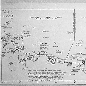
Map of Corsica (France) (etching, 1730)
 (etching, 1730)")
![]()
Wall Art and Photo Gifts from Fine Art Finder
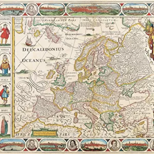
Map of Corsica (France) (etching, 1730)
LRI4707105 Map of Corsica (France) (etching, 1730) by Delisle, Guillaume (1675-1726); Private Collection; (add.info.: Map of Corsica (France) - Strong water extracted from the " New Atlas containing all parts of the world" 1730 by Guillaume de L Isle (1675-1726)); Luisa Ricciarini; French, out of copyright
Media ID 23734574
© Luisa Ricciarini / Bridgeman Images
Atlas Book Corsican Geographical Map
FEATURES IN THESE COLLECTIONS
> Fine Art Finder
> Artists
> Franz Hogenberg
> Fine Art Finder
> Artists
> Guillaume Delisle
> Maps and Charts
> Related Images
> Maps and Charts
> World
EDITORS COMMENTS
This print showcases a remarkable etching from 1730, depicting the "Map of Corsica" by Guillaume Delisle. The intricate details and delicate lines of this historical map are beautifully preserved in this print, allowing us to admire the craftsmanship and artistry that went into its creation. Corsica, an enchanting island located in France, is brought to life through this geographical masterpiece. As we explore the contours and features meticulously outlined on the map, we can almost imagine ourselves traversing its rugged mountains and idyllic coastlines. Originally extracted from the renowned "New Atlas containing all parts of the world" published in 1730 by Guillaume de L'Isle, this particular map holds immense historical significance. It provides us with a glimpse into how people perceived and understood geography during the 18th century. Luisa Ricciarini has skillfully captured every detail of this etching, ensuring that it remains accessible for generations to come. Through her lens, we are transported back in time to appreciate not only Corsica's natural beauty but also its place within European history. As we gaze upon this stunning print, let us marvel at both the artistic mastery behind it and the invaluable insights it offers into our past. This piece serves as a reminder of how maps have long been cherished as windows into different worlds – guiding explorers and igniting curiosity throughout centuries gone by.
MADE IN THE USA
Safe Shipping with 30 Day Money Back Guarantee
FREE PERSONALISATION*
We are proud to offer a range of customisation features including Personalised Captions, Color Filters and Picture Zoom Tools
SECURE PAYMENTS
We happily accept a wide range of payment options so you can pay for the things you need in the way that is most convenient for you
* Options may vary by product and licensing agreement. Zoomed Pictures can be adjusted in the Cart.