Home > Europe > Iceland > Maps
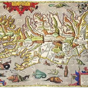
Map: Iceland, according to the Trigon Survey of Gunnlaugsson drawn by Augustus Petermann (colour litho)
")
![]()
Wall Art and Photo Gifts from Fine Art Finder
Map: Iceland, according to the Trigon Survey of Gunnlaugsson drawn by Augustus Petermann (colour litho)
6004697 Map: Iceland, according to the Trigon Survey of Gunnlaugsson drawn by Augustus Petermann (colour litho) by English School, (19th century); Private Collection; (add.info.: Iceland, according to the Trigon Survey of Gunnlaugsson drawn by Augustus Petermann. Illustration for A Gazetteer of the World or Dictionary of Geographical Knowledge (A Fullarton, 1858).); © Look and Learn
Media ID 22577388
© Look and Learn / Bridgeman Images
1850s Iceland Icelander Icelandic Victoria
FEATURES IN THESE COLLECTIONS
> Europe
> Iceland
> Related Images
> Fine Art Finder
> Artists
> English School
> Fine Art Finder
> Artists
> European School
> Maps and Charts
> Early Maps
> Maps and Charts
> Related Images
> Maps and Charts
> World
EDITORS COMMENTS
This print showcases a beautifully detailed map of Iceland, meticulously drawn by Augustus Petermann based on the Trigon Survey of Gunnlaugsson. The vibrant colors and intricate lines bring this 19th-century masterpiece to life, offering a glimpse into the historical geography of Iceland. Commissioned for A Gazetteer of the World or Dictionary of Geographical Knowledge in 1858, this map serves as a valuable resource for understanding the Icelandic landscape during that time. It provides an invaluable insight into the country's topography, highlighting its mountains, rivers, and coastlines with remarkable precision. The artistry displayed in this lithograph is truly commendable; every stroke captures the essence of Iceland's unique beauty. From its jagged cliffs to its sprawling glaciers, each element is carefully depicted to transport viewers back to a bygone era. As we gaze upon this piece from our private collection today, it offers us not only a visual feast but also an opportunity to delve into history. This map reminds us of how far cartography has come and how crucial it was in shaping our understanding of different regions around the world. Whether you are an avid historian or simply appreciate fine art, this extraordinary print invites you on a journey through time and space – inviting you to explore Iceland through the eyes of Augustus Petermann and his meticulous surveying techniques.
MADE IN THE USA
Safe Shipping with 30 Day Money Back Guarantee
FREE PERSONALISATION*
We are proud to offer a range of customisation features including Personalised Captions, Color Filters and Picture Zoom Tools
SECURE PAYMENTS
We happily accept a wide range of payment options so you can pay for the things you need in the way that is most convenient for you
* Options may vary by product and licensing agreement. Zoomed Pictures can be adjusted in the Cart.