Home > Arts > Artists > B > Joan Blaeu
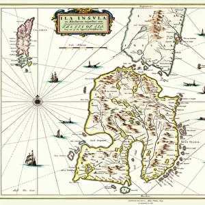
Map of Valois, 1926 (print)
")
![]()
Wall Art and Photo Gifts from Fine Art Finder
Map of Valois, 1926 (print)
3786712 Map of Valois, 1926 (print) by Blaeu, Willem (1571-1638) and Joan (1596-1673); Private Collection; (add.info.: by Willem and Joan Blaeu.
Historic region in the valley of the Oise river in Picardy, France. Originally pagus valensis. (Full title: Tooneel des Aerdrycx, ofte nieuew Atlas, dat is beschryving van alle Landen; nu nieulycx uytgegeven door Wilhelm en Johanne Blaeu').
Old Decorative Maps and Charts by Arthur L. Humphreys, 1926.); Lebrecht History
Media ID 33085476
© Lebrecht History / Bridgeman Images
17th Centuries Blazon Cartographer Coat Of Arm Coat Or Arms Countries Earth Geographer Globe Heraldic Heraldic Symbols Picardy Seventeenth 17 17th 17th 17th Xvii 18th Century Circa 1600 Early 17th Century Early Xvii Century Francais Heraldry Seventeeth Century
FEATURES IN THESE COLLECTIONS
> Arts
> Artists
> B
> Joan Blaeu
> Arts
> Artists
> B
> Willem Blaeu
> Europe
> France
> Canton
> Oise
> Fine Art Finder
> Artists
> Etruscan
> Fine Art Finder
> Artists
> Willem and Joan (1596-1673) Blaeu
> Maps and Charts
> Early Maps
> Popular Themes
> Maps and Charts
EDITORS COMMENTS
This print showcases the "Map of Valois, 1926" by Willem and Joan Blaeu. The map depicts the historic region in the valley of the Oise river in Picardy, France. Originally known as pagus valensis, Valois holds a rich history that is beautifully represented in this intricate cartographic masterpiece. The map is part of a larger collection titled "Tooneel des Aerdrycx, ofte nieuew Atlas" which translates to "Theater of the World or New Atlas". Published by Wilhelm and Johanne Blaeu, this atlas provides a comprehensive description of various lands during its time. Adorned with vibrant colors and exquisite detail, this print captures not only geographical information but also heraldic symbols such as coats of arms. It offers a glimpse into European geography during the seventeenth century. With its meticulous craftsmanship and historical significance, this print serves as both an educational tool for geographers and an artistic representation of France's past. Its inclusion in Old Decorative Maps and Charts by Arthur L. Humphreys further solidifies its value as a treasured piece within private collections. Bridgeman Images has preserved this remarkable artwork through Fine Art Finder, allowing viewers to appreciate the beauty and intricacy it possesses. Whether you are interested in cartography or simply captivated by historical maps, this print is sure to transport you back to seventeenth-century Europe while celebrating French heritage.
MADE IN THE USA
Safe Shipping with 30 Day Money Back Guarantee
FREE PERSONALISATION*
We are proud to offer a range of customisation features including Personalised Captions, Color Filters and Picture Zoom Tools
SECURE PAYMENTS
We happily accept a wide range of payment options so you can pay for the things you need in the way that is most convenient for you
* Options may vary by product and licensing agreement. Zoomed Pictures can be adjusted in the Cart.