Home > Europe > United Kingdom > England > London > Towns > Islington
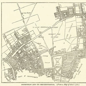
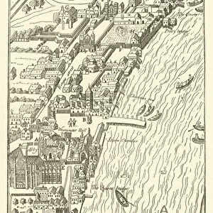
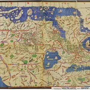
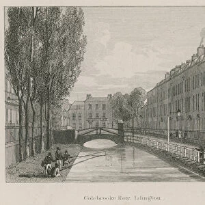
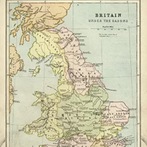
Map of Islington, Clerkenwell, Holborn and Finsbury (engraving)
")
![]()
Wall Art and Photo Gifts from Fine Art Finder
Map of Islington, Clerkenwell, Holborn and Finsbury (engraving)
983861 Map of Islington, Clerkenwell, Holborn and Finsbury (engraving) by English School, (18th century); Private Collection; (add.info.: Map of Islington, Clerkenwell, Holborn and Finsbury.); Look and Learn / Peter Jackson Collection
Media ID 22203418
© Look and Learn / Peter Jackson Collection / Bridgeman Images
Clerkenwell Fields Finsbury Fields Holborn Islington
FEATURES IN THESE COLLECTIONS
> Europe
> Related Images
> Europe
> United Kingdom
> England
> London
> Boroughs
> Islington
> Europe
> United Kingdom
> England
> London
> Related Images
> Europe
> United Kingdom
> England
> London
> Towns
> Islington
> Europe
> United Kingdom
> England
> Maps
> Europe
> United Kingdom
> England
> Posters
> Europe
> United Kingdom
> Maps
> Europe
> United Kingdom
> Related Images
> Fine Art Finder
> Artists
> English School
> Fine Art Finder
> Temp Classification
EDITORS COMMENTS
This 18th-century engraving showcases a detailed map of Islington, Clerkenwell, Holborn, and Finsbury. The intricate lines and delicate etchings transport us back in time to the bustling streets of London during this era. With its rich history and cultural significance, this print offers a glimpse into the geography and layout of these iconic neighborhoods. The map highlights various landmarks such as Finsbury Fields, Conduitfields, and Clerkenwell. It provides an invaluable resource for understanding the development of these areas over time. From the open fields to the bustling cityscape we know today, it is fascinating to see how urbanization has transformed this part of England. As we examine this piece further, it becomes evident that it holds not only historical value but also reflects British culture and identity. The attention to detail in depicting street names and architectural features demonstrates the meticulousness with which maps were created during this period. Whether you are a history enthusiast or simply intrigued by cartography, this print serves as a window into both past landscapes and British heritage. Its presence in private collections ensures its preservation for future generations to appreciate. Let yourself be transported through time as you explore every intricacy within this remarkable engraving from Fine Art Finder's collection by Bridgeman Images.
MADE IN THE USA
Safe Shipping with 30 Day Money Back Guarantee
FREE PERSONALISATION*
We are proud to offer a range of customisation features including Personalised Captions, Color Filters and Picture Zoom Tools
SECURE PAYMENTS
We happily accept a wide range of payment options so you can pay for the things you need in the way that is most convenient for you
* Options may vary by product and licensing agreement. Zoomed Pictures can be adjusted in the Cart.