Home > Europe > United Kingdom > England > London > Museums > National Maritime Museum
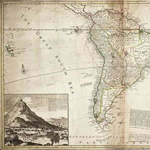
Map of North America, c. 1720 (engraving)
")
![]()
Wall Art and Photo Gifts from Fine Art Finder
Map of North America, c. 1720 (engraving)
7340006 Map of North America, c. 1720 (engraving) by Vertue, George (1684-1756); National Maritime Museum, London, UK; (add.info.: Creator: Moll, Herman ; B. Lens, delin. ; G. Vertue, sculp.
Title cartouche: indigenous people & products. Shows tracks of voyages into Hudsons Bay. View: Newfoundland cod fishery. Text panel about the Spanish treasure fleet.); © National Maritime Museum, Greenwich, London
Media ID 38288626
© © National Maritime Museum, Greenwich, London / Bridgeman Images
FEATURES IN THESE COLLECTIONS
> Arts
> Artists
> M
> Herman Moll
> Arts
> Artists
> V
> George Vertue
> Europe
> United Kingdom
> England
> London
> Boroughs
> Greenwich
> Europe
> United Kingdom
> England
> London
> Museums
> Greenwich Heritage Centre
> Europe
> United Kingdom
> England
> London
> Museums
> National Maritime Museum
> Europe
> United Kingdom
> England
> London
> Towns
> Greenwich
> Europe
> United Kingdom
> Heritage Sites
> Maritime Greenwich
> Europe
> United Kingdom
> Maps
> Fine Art Finder
> Artists
> British School
> Fine Art Finder
> Artists
> George Vertue
EDITORS COMMENTS
This stunning engraving from 1720 showcases a detailed map of North America, created by Herman Moll and beautifully engraved by George Vertue. The intricate details on the map include indigenous people and products in the title cartouche, tracks of voyages into Hudson's Bay, and a view of the Newfoundland cod fishery. Additionally, there is a text panel about the Spanish treasure fleet, adding to the historical significance of this piece.
The map provides a glimpse into early 18th-century cartography, highlighting the coastlines and maritime features of North America with precision. From Canada to the United States, every detail is meticulously captured by these talented geographers and engravers.
As you study this print closely, you can appreciate the artistry and skill that went into creating such a masterpiece. The lines and shading bring each element to life, making it feel as though you are looking at an actual snapshot of history.
Whether you are a geography enthusiast or simply appreciate fine art, this Map of North America from 1720 is sure to captivate your imagination and transport you back in time to an era when exploration was at its peak.
MADE IN THE USA
Safe Shipping with 30 Day Money Back Guarantee
FREE PERSONALISATION*
We are proud to offer a range of customisation features including Personalised Captions, Color Filters and Picture Zoom Tools
SECURE PAYMENTS
We happily accept a wide range of payment options so you can pay for the things you need in the way that is most convenient for you
* Options may vary by product and licensing agreement. Zoomed Pictures can be adjusted in the Cart.