Home > Europe > United Kingdom > England > London > Museums > National Maritime Museum
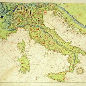
Tirao [and] Tolten, 1685 (manuscript)
![Tirao [and] Tolten, 1685 (manuscript)](/p/690/tirao-and-tolten-1685-manuscript-38372712.jpg.webp "Tirao [and] Tolten, 1685 (manuscript)")
![]()
Wall Art and Photo Gifts from Fine Art Finder
Tirao [and] Tolten, 1685 (manuscript)
7339774 Tirao [and] Tolten, 1685 (manuscript) by Hack, William (17th Century); 40.5x5 cm; National Maritime Museum, London, UK; (add.info.: Creator: William Hack
Bound in 'A Wagoner of the South Sea describeing the sea coast from acapulco to Albemarle isle', an English translation of a Spanish derrotero captured from the Spanish ship 'Rosario' by Captain Bartholomew Sharpe in 1680. Hack made multiple copies of this atlas. This one was presented to James II.); © National Maritime Museum, Greenwich, London
Media ID 38372712
© © National Maritime Museum, Greenwich, London / Bridgeman Images
Coast Line Colony Latin America
FEATURES IN THESE COLLECTIONS
> Arts
> Artists
> J
> William James
> Europe
> United Kingdom
> England
> London
> Boroughs
> Greenwich
> Europe
> United Kingdom
> England
> London
> Museums
> Greenwich Heritage Centre
> Europe
> United Kingdom
> England
> London
> Museums
> National Maritime Museum
> Europe
> United Kingdom
> England
> London
> Towns
> Greenwich
> Europe
> United Kingdom
> Heritage Sites
> Maritime Greenwich
> Europe
> United Kingdom
> Maps
> Fine Art Finder
> Artists
> Battista Agnese
> Fine Art Finder
> Artists
> William Hack
> Maps and Charts
> Early Maps
EDITORS COMMENTS
This stunning print captures a glimpse of history with the manuscript titled "Tirao and Tolten, 1685" by William Hack. The intricate details and vibrant colors bring to life a piece of cartography from the 17th century, showcasing the coastlines of South America during this time period.
Bound in 'A Wagoner of the South Sea describing the sea coast from Acapulco to Albemarle Isle', this English translation of a Spanish derrotero was captured from the Spanish ship 'Rosario' by Captain Bartholomew Sharpe in 1680. William Hack meticulously created multiple copies of this atlas, with one presented to James II.
The map provides a fascinating insight into colonial exploration and maritime navigation during this era, highlighting Spain's influence on Latin America. The coastal scenes depicted in vivid color transport viewers back in time to an age when cartographers painstakingly mapped out uncharted territories for future generations.
As you gaze upon this remarkable piece of history, you can't help but marvel at the skill and artistry that went into creating such detailed manuscripts. This print serves as a reminder of our rich past and the importance of preserving these historical treasures for future generations to appreciate.
MADE IN THE USA
Safe Shipping with 30 Day Money Back Guarantee
FREE PERSONALISATION*
We are proud to offer a range of customisation features including Personalised Captions, Color Filters and Picture Zoom Tools
SECURE PAYMENTS
We happily accept a wide range of payment options so you can pay for the things you need in the way that is most convenient for you
* Options may vary by product and licensing agreement. Zoomed Pictures can be adjusted in the Cart.