Home > Europe > United Kingdom > England > London > Museums > National Maritime Museum
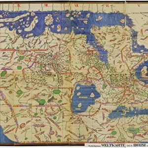
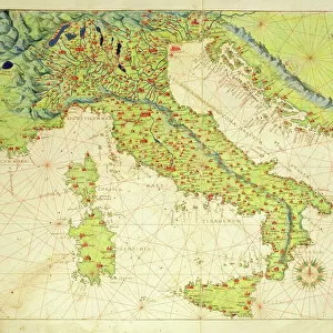
Map of Scandinavia, 1554 (vellum)
")
![]()
Wall Art and Photo Gifts from Fine Art Finder
Map of Scandinavia, 1554 (vellum)
7339651 Map of Scandinavia, 1554 (vellum) by Agnese, Battista (c.1500-64); 26x40 cm; National Maritime Museum, London, UK; (add.info.: Creator: Battista Agnese
Bound in an atlas of twenty-four cartographic items titled: 'Seekarten von Battista Agnese Anno MDLIV.d.IV.May.' The atlas also includes astronomical tables and diagrams. Text in Latin, titles and place names in German outside borders.); © National Maritime Museum, Greenwich, London
Media ID 38288516
© © National Maritime Museum, Greenwich, London / Bridgeman Images
FEATURES IN THESE COLLECTIONS
> Arts
> Artists
> A
> Battista Agnese
> Europe
> United Kingdom
> England
> London
> Boroughs
> Greenwich
> Europe
> United Kingdom
> England
> London
> Museums
> Greenwich Heritage Centre
> Europe
> United Kingdom
> England
> London
> Museums
> National Maritime Museum
> Europe
> United Kingdom
> England
> London
> Towns
> Greenwich
> Europe
> United Kingdom
> Heritage Sites
> Maritime Greenwich
> Europe
> United Kingdom
> Maps
> Fine Art Finder
> Artists
> Battista Agnese
EDITORS COMMENTS
This stunning print captures the intricate and detailed Map of Scandinavia from 1554, created by Battista Agnese. The map, measuring 26x40 cm, is a masterpiece of cartography from the 16th century.
Bound in an atlas of twenty-four cartographic items titled 'Seekarten von Battista Agnese Anno MDLIV.d.IV.May,' this map is just one part of a larger collection that includes astronomical tables and diagrams. The text on the map is in Latin, with titles and place names in German outside the borders.
The colors used in this map are vibrant and eye-catching, adding to its overall beauty as a work of art. The attention to detail in depicting the various regions of Scandinavia is truly remarkable.
This piece serves as not only a valuable historical document but also as a stunning visual representation of the Scandinavian region during the 16th century. It offers viewers a glimpse into the past and allows them to appreciate both the artistry and scientific precision involved in creating such maps.
Overall, this print provides a fascinating look at an important piece of cartographic history, showcasing Battista Agnese's skill and expertise in creating maps that were both informative and visually striking.
MADE IN THE USA
Safe Shipping with 30 Day Money Back Guarantee
FREE PERSONALISATION*
We are proud to offer a range of customisation features including Personalised Captions, Color Filters and Picture Zoom Tools
SECURE PAYMENTS
We happily accept a wide range of payment options so you can pay for the things you need in the way that is most convenient for you
* Options may vary by product and licensing agreement. Zoomed Pictures can be adjusted in the Cart.