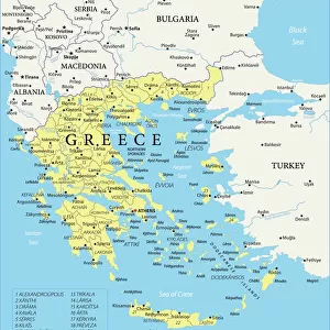
Home > Europe > Russia > Lakes > Caspian Sea
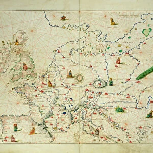
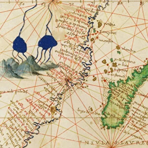
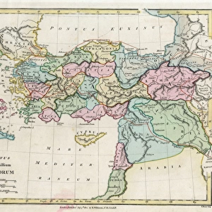
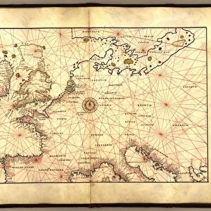
Europe and Central Asia, from an Atlas of the World in 33 Maps, Venice, 1st September 1553

![]()
Wall Art and Photo Gifts from Fine Art Finder
Europe and Central Asia, from an Atlas of the World in 33 Maps, Venice, 1st September 1553
XOT330953 Europe and Central Asia, from an Atlas of the World in 33 Maps, Venice, 1st September 1553 (ink on vellum) (see also 330954) by Agnese, Battista (1514-64); 29x49 cm; Museo Correr, Venice, Italy; Italian, out of copyright
Media ID 12852666
© www.bridgemanart.com
Cartography Caspian Sea Chart Mapping Mediterranean Navigation Portolan
FEATURES IN THESE COLLECTIONS
> Arts
> Artists
> A
> Battista Agnese
> Asia
> Turkey
> Related Images
> Europe
> Italy
> Veneto
> Venice
> Europe
> Russia
> Lakes
> Caspian Sea
> Fine Art Finder
> Artists
> Battista Agnese
> Fine Art Finder
> Maps (celestial & Terrestrial)
> Maps and Charts
> Italy
EDITORS COMMENTS
This print showcases a remarkable piece of cartographic history, an Atlas of the World in 33 Maps created by Battista Agnese on September 1st, 1553. The intricate details and artistry of this ink on vellum masterpiece transport us back to a time when exploration and navigation were at their peak. The image captures Europe and Central Asia, offering a glimpse into the geographical knowledge of the era. From the Caspian Sea to the Mediterranean, Greece to Turkey, and Russia beyond, this map reveals how these regions were perceived during that period. Agnese's expertise as a renowned Italian cartographer is evident in every stroke. His meticulous attention to detail brings life to each coastline, mountain range, and city depicted on this map. It serves not only as a navigational tool but also as an exquisite work of art. Displayed at Museo Correr in Venice today, this historical artifact reminds us of humanity's insatiable curiosity for discovery. It symbolizes our relentless pursuit to understand our world better through mapping its vast landscapes. As we gaze upon this ancient treasure from centuries past, we are reminded that maps have always been more than just practical tools; they hold within them stories of adventure and human ingenuity. This particular piece invites us to appreciate both the beauty inherent in cartography and its invaluable role in shaping our understanding of geography throughout history.
MADE IN THE USA
Safe Shipping with 30 Day Money Back Guarantee
FREE PERSONALISATION*
We are proud to offer a range of customisation features including Personalised Captions, Color Filters and Picture Zoom Tools
SECURE PAYMENTS
We happily accept a wide range of payment options so you can pay for the things you need in the way that is most convenient for you
* Options may vary by product and licensing agreement. Zoomed Pictures can be adjusted in the Cart.