Home > Europe > United Kingdom > England > London > Museums > National Maritime Museum
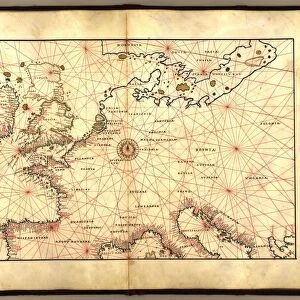
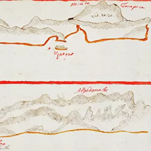
Chart of Negroponte, 1554 (vellum)
")
![]()
Wall Art and Photo Gifts from Fine Art Finder
Chart of Negroponte, 1554 (vellum)
7339644 Chart of Negroponte, 1554 (vellum) by Agnese, Battista (c.1500-64); 26x40 cm; National Maritime Museum, London, UK; (add.info.: Creator: Battista Agnese
Scale: 1:1 200 000 and at North at 315 degrees. The chart also has iconography, cities, the Acropolis at Athens and one ship.); © National Maritime Museum, Greenwich, London
Media ID 38339714
© © National Maritime Museum, Greenwich, London / Bridgeman Images
Islands Isles Art Fine Art C16h Geographer Greece Greek
FEATURES IN THESE COLLECTIONS
> Arts
> Artists
> A
> Battista Agnese
> Europe
> Greece
> Heritage Sites
> Acropolis, Athens
> Europe
> United Kingdom
> England
> London
> Boroughs
> Greenwich
> Europe
> United Kingdom
> England
> London
> Museums
> Greenwich Heritage Centre
> Europe
> United Kingdom
> England
> London
> Museums
> National Maritime Museum
> Europe
> United Kingdom
> England
> London
> Towns
> Greenwich
> Europe
> United Kingdom
> Heritage Sites
> Maritime Greenwich
> Europe
> United Kingdom
> Maps
> Fine Art Finder
> Artists
> Basil Ringrose
> Fine Art Finder
> Artists
> Battista Agnese
EDITORS COMMENTS
This stunning print captures the intricate and detailed Chart of Negroponte from 1554, created by Battista Agnese. The chart, made on vellum, showcases a scale of 1:1 200 000 with North at 315 degrees. It features iconography, cities, the Acropolis at Athens, and even a single ship sailing through the waters.
Battista Agnese's expertise in cartography is evident in this masterpiece from the 16th century. The vibrant colors bring life to the map, highlighting various regions and landmarks with precision. The artistry and skill involved in creating such a detailed work of art are truly remarkable.
As you gaze upon this piece from the National Maritime Museum in London, you can't help but be transported back in time to an era of exploration and discovery. The map not only serves as a navigational tool but also as a work of art that reflects the beauty and complexity of geography.
From Greece to Europe, this chart provides a glimpse into historical maritime routes and trade networks that shaped civilizations centuries ago. It is a testament to human ingenuity and curiosity about the world around us.
In owning this photo print, you hold a piece of history in your hands – a window into the past that continues to inspire awe and wonder today.
MADE IN THE USA
Safe Shipping with 30 Day Money Back Guarantee
FREE PERSONALISATION*
We are proud to offer a range of customisation features including Personalised Captions, Color Filters and Picture Zoom Tools
SECURE PAYMENTS
We happily accept a wide range of payment options so you can pay for the things you need in the way that is most convenient for you
* Options may vary by product and licensing agreement. Zoomed Pictures can be adjusted in the Cart.