Home > Europe > Spain > Maps
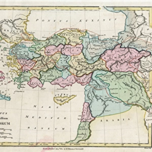
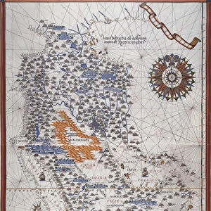
Map of the eastern part of the Mediterranean and the Black Sea

![]()
Wall Art and Photo Gifts from Fine Art Finder
Map of the eastern part of the Mediterranean and the Black Sea
AIS5369945 Map of the eastern part of the Mediterranean and the Black Sea, manuscript of a 16th century portolan atlas (manuscript) by Martines, Joan (16th century); Museu Maritim Atarazanas, Barcelona, Catalunya, Spain; (add.info.: Attributed to Joan Martines (active 1556 to 1591) or his workshop.); eIberfoto; Spanish, out of copyright
Media ID 23712146
© Iberfoto / Bridgeman Images
Atlas Book Of Maps Black Sea Geographical Map Mediterranean Mediterranean Sea Turkey Turkish Turk
FEATURES IN THESE COLLECTIONS
> Asia
> Turkey
> Related Images
> Europe
> Spain
> Related Images
> Fine Art Finder
> Artists
> Andreas Cellarius
> Fine Art Finder
> Artists
> Joan Martines
> Maps and Charts
> Related Images
EDITORS COMMENTS
This print showcases a meticulously detailed map of the eastern part of the Mediterranean and the Black Sea. Created in the 16th century, this manuscript is believed to be from a portolan atlas by Joan Martines or his workshop. The Map offers an intriguing glimpse into historical cartography, with its vibrant colors and intricate illustrations. The Map depicts various countries and regions including France, Turkey, and other European nations that border these seas. It serves as a testament to the rich maritime history of this region during that era. The artist's skillful use of color brings life to each element on the map, making it visually appealing even after centuries have passed. As we delve into this ancient artwork, we are transported back in time when maps were not only tools for navigation but also works of art. This masterpiece combines both functionality and aesthetic appeal seamlessly. Displayed at Museu Maritim Atarazanas in Barcelona, Catalunya, Spain; this remarkable piece has been preserved for generations to appreciate its historical significance. Its presence reminds us of how far cartography has come since then while still appreciating the beauty found within these early maps. Bridgeman Images has captured every detail flawlessly in this photo print, allowing viewers to admire the intricacies up close. Whether you are an art enthusiast or history buff, this image will surely captivate your imagination and transport you back to a time long gone by.
MADE IN THE USA
Safe Shipping with 30 Day Money Back Guarantee
FREE PERSONALISATION*
We are proud to offer a range of customisation features including Personalised Captions, Color Filters and Picture Zoom Tools
SECURE PAYMENTS
We happily accept a wide range of payment options so you can pay for the things you need in the way that is most convenient for you
* Options may vary by product and licensing agreement. Zoomed Pictures can be adjusted in the Cart.