Home > Arts > Artists > C > Abraham Cresques
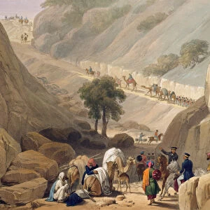
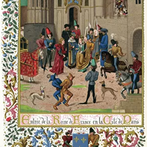
Detail of a Catalan nautical chart (portulan) representing Asia of the 13th century
 representing Asia of the 13th century")
![]()
Wall Art and Photo Gifts from Fine Art Finder
Detail of a Catalan nautical chart (portulan) representing Asia of the 13th century
JLJ4601120 Detail of a Catalan nautical chart (portulan) representing Asia of the 13th century, on which one can see a caravan walking towards Cathay (name given by Marco Polo to design the region of North China): Silk Route taken by Marco Polo. Catalan Atlas by Abraham Cresques (1325-1387), manuscript enluminated on parchment, Mallorca (Mallorca, Mallorca), 1375. B.N, Paris by Catalan School, (14th century); Bibliotheque Nationale, Paris, France; (add.info.: Detail of a Catalan nautical chart (portulan) representing Asia of the 13th century, on which one can see a caravan walking towards Cathay (name given by Marco Polo to design the region of North China): Silk Route taken by Marco Polo. Catalan Atlas by Abraham Cresques (1325-1387), manuscript enluminated on parchment, Mallorca (Mallorca, Mallorca), 1375. B.N, Paris); Photo ePhoto Josse; Spanish, out of copyright
Media ID 23722686
© Josse / Bridgeman Images
13 13e 13eme Xiii Xiiie Xiiieme Siecle Asie Asiatique Asiatiques Camel Caravan Caravane Carte Geographique Chameau Chine Chinois Chinoise Chinoises Decouverte Enluminure Explorateur Geographie Marco 1254 1324 Moyen Age Polo Silk Soie Asian Asian Geographical Map
FEATURES IN THESE COLLECTIONS
> Arts
> Artists
> C
> Abraham Cresques
> Arts
> Artists
> C
> Catalan School Catalan School
> Arts
> Artists
> S
> Spanish School
> Asia
> Related Images
> Europe
> France
> Paris
> Maps
> Europe
> France
> Paris
> Related Images
> Fine Art Finder
> Artists
> Andrea del Sarto
> Fine Art Finder
> Artists
> Catalan School
EDITORS COMMENTS
This print showcases a detailed Catalan nautical chart from the 13th century, specifically representing Asia. The chart, created by Abraham Cresques in 1375, is an illuminated manuscript on parchment and is currently housed at the Bibliotheque Nationale in Paris. In this particular detail of the chart, we can observe a caravan making its way towards Cathay, which was Marco Polo's term for North China. This depiction highlights the Silk Route taken by Marco Polo during his famous journey through Asia. The inclusion of this caravan adds depth and historical significance to the map. The artwork itself is a testament to the skill and craftsmanship of the Catalan School during the 14th century. The intricate details and vibrant colors used in this illumination are truly remarkable. This image not only provides insight into medieval geographical knowledge but also offers glimpses into exploration and discovery during that time period. It serves as a visual representation of Marco Polo's travels along with other significant trade routes like the Silk Road. Overall, this photograph captures both artistic beauty and historical importance within one frame. It invites viewers to delve into centuries-old cartography while appreciating its aesthetic value as well.
MADE IN THE USA
Safe Shipping with 30 Day Money Back Guarantee
FREE PERSONALISATION*
We are proud to offer a range of customisation features including Personalised Captions, Color Filters and Picture Zoom Tools
SECURE PAYMENTS
We happily accept a wide range of payment options so you can pay for the things you need in the way that is most convenient for you
* Options may vary by product and licensing agreement. Zoomed Pictures can be adjusted in the Cart.