Home > Europe > France > Canton > Charente
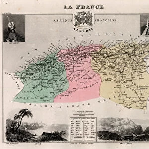
La Charente (16), Poitou-Charentes (Poitou Charentes) - France and its Colonies. Atlas illustrates one hundred and five maps from the maps of the depot of war, bridges and footwear and the Navy by M. VUILLEMIN. 1876
, Poitou-Charentes (Poitou Charentes) - France and its Colonies. Atlas illustrates one hundred and five maps from the maps of the depot of war, bridges and footwear and the Navy by M. VUILLEMIN. 1876")
![]()
Wall Art and Photo Gifts from Fine Art Finder
La Charente (16), Poitou-Charentes (Poitou Charentes) - France and its Colonies. Atlas illustrates one hundred and five maps from the maps of the depot of war, bridges and footwear and the Navy by M. VUILLEMIN. 1876
XEE4144617 La Charente (16), Poitou-Charentes (Poitou Charentes) - France and its Colonies. Atlas illustrates one hundred and five maps from the maps of the depot of war, bridges and footwear and the Navy by M. VUILLEMIN. 1876. by Vuillemin, Alexandre (1812-1886); Private Collection; (add.info.: La Charente (16), Poitou-Charentes (Poitou Charentes) - France and its Colonies. Atlas illustrates one hundred and five maps from the maps of the depot of war, bridges and footwear and the Navy by M. VUILLEMIN. 1876.); Stefano Bianchetti; French, out of copyright
Media ID 25183058
© Stefano Bianchetti / Bridgeman Images
Atlas Book Charente 16 Chestle Geographical Map
FEATURES IN THESE COLLECTIONS
> Europe
> France
> Canton
> Charente
> Fine Art Finder
> Artists
> Alexandre Vuillemin
> Maps and Charts
> Related Images
> Services
> Royal Navy
EDITORS COMMENTS
This print showcases a stunning geographical map titled "La Charente (16), Poitou-Charentes - France and its Colonies". The map is part of an atlas that features one hundred and five meticulously crafted maps from the esteemed depot of war, bridges, footwear, and the Navy by M. VUILLEMIN in 1876. The intricate details of this engraving take us on a visual journey through the region of Poitou-Charentes in France and its colonies. Every contour, river, city, and border has been expertly depicted to provide an accurate representation of the area. Created by Alexandre Vuillemin (1812-1886), this masterpiece captures both historical significance and artistic brilliance. The colors used in this map add depth and vibrancy to each element showcased within it. It is evident that every stroke was carefully executed with precision. Displayed against a backdrop reminiscent of an antique book cover, this print exudes a sense of nostalgia while also serving as a valuable educational resource for those interested in French geography or history. Its timeless beauty makes it suitable for any space – be it a study room or an art gallery. Stefano Bianchetti's exceptional photography skills have flawlessly captured every detail, ensuring that viewers can appreciate the intricacies even from afar. This photograph truly encapsulates the essence of cartography as both science and artistry come together harmoniously on paper.
MADE IN THE USA
Safe Shipping with 30 Day Money Back Guarantee
FREE PERSONALISATION*
We are proud to offer a range of customisation features including Personalised Captions, Color Filters and Picture Zoom Tools
SECURE PAYMENTS
We happily accept a wide range of payment options so you can pay for the things you need in the way that is most convenient for you
* Options may vary by product and licensing agreement. Zoomed Pictures can be adjusted in the Cart.