Home > Maps and Charts > Abraham Ortelius
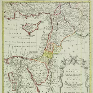
Palestine and the Promised Land, from the Theatrum Orbis Terrarum, 1603

![]()
Wall Art and Photo Gifts from Fine Art Finder
Palestine and the Promised Land, from the Theatrum Orbis Terrarum, 1603
XOT366567 Palestine and the Promised Land, from the Theatrum Orbis Terrarum, 1603 (coloured engraving) by Ortelius, Abraham (1527-98) (after); Private Collection; (add.info.: The first edition of Theatrum Orbis Terrarum was published in 1570 and is reputed to be the first modern atlas; ); Flemish, out of copyright
Media ID 12867521
© www.bridgemanart.com
Holy Land Israel Mapping Mediterranean
FEATURES IN THESE COLLECTIONS
> Fine Art Finder
> Artists
> Abraham (after) Ortelius
> Maps and Charts
> Abraham Ortelius
EDITORS COMMENTS
This print showcases a coloured engraving titled "Palestine and the Promised Land" from the renowned Theatrum Orbis Terrarum, dating back to 1603. Created by Abraham Ortelius, a Flemish cartographer of great repute, this masterpiece is part of a private collection. The Theatrum Orbis Terrarum is widely regarded as the first modern atlas and was initially published in 1570. It revolutionized mapmaking by providing comprehensive geographical information in one consolidated volume. This particular engraving focuses on Palestine and its neighboring regions, including Israel, Egypt, and the Mediterranean. The intricate details depicted in this piece offer an invaluable glimpse into historical mapping techniques. As we explore this ancient rendition of the Holy Land, we are transported back in time to an era when cartography was still evolving. With its vibrant colors and meticulous craftsmanship, this print not only serves as a visual delight but also offers valuable insights into Middle Eastern geography during that period. It reminds us of the significance attached to these lands throughout history - lands that have been considered sacred by various cultures for centuries. As we admire this remarkable artwork captured by Fine Art Finder from www. bridgemanart. com, let us appreciate both its aesthetic beauty and its contribution to our understanding of past civilizations' perceptions of land and boundaries.
MADE IN THE USA
Safe Shipping with 30 Day Money Back Guarantee
FREE PERSONALISATION*
We are proud to offer a range of customisation features including Personalised Captions, Color Filters and Picture Zoom Tools
SECURE PAYMENTS
We happily accept a wide range of payment options so you can pay for the things you need in the way that is most convenient for you
* Options may vary by product and licensing agreement. Zoomed Pictures can be adjusted in the Cart.