Home > Arts > Artists > A > Battista Agnese
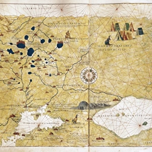
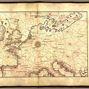
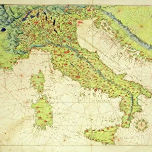
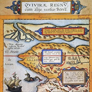
Moschoviae Tabula, map of Russia and European cities along the Volga River

![]()
Wall Art and Photo Gifts from Fine Art Finder
Moschoviae Tabula, map of Russia and European cities along the Volga River
AIS5334417 Moschoviae Tabula, map of Russia and European cities along the Volga River, 1525 (colour manuscript) by Agnese, Battista (1514-64); Biblioteca Nazionale Marciana, Venice, Italy; (add.info.: Moschoviae Tabula, map of Russia and European cities along the Volga River. Considered as the oldest map of Russia. Colourful manuscript, 1525, by Battista Agnese (ca. 1500-1564) from the descriptions of Paolo Giovio (Paul Jove, 1483-1552). Biblioteca nazionale marciana, Venice (Italy).); eIberfoto; Italian, out of copyright
Media ID 22584922
© Iberfoto / Bridgeman Images
Atlas Book Of Maps Cartography Geographical Map Cinquecento
FEATURES IN THESE COLLECTIONS
> Arts
> Artists
> A
> Battista Agnese
> Arts
> Landscape paintings
> Waterfall and river artworks
> River artworks
> Asia
> Related Images
> Europe
> Italy
> Veneto
> Venice
> Fine Art Finder
> Artists
> (1528-88) Veronese
> Fine Art Finder
> Artists
> Battista Agnese
> Maps and Charts
> Italy
EDITORS COMMENTS
This vibrant and intricate print captures the "Moschoviae Tabula" a map of Russia and European cities along the Volga River. Created in 1525 by Battista Agnese, this colourful manuscript is considered to be the oldest map of Russia. Housed in the Biblioteca Nazionale Marciana in Venice, Italy, it showcases Agnese's exceptional cartography skills. The map provides a fascinating glimpse into 16th-century geography, with detailed depictions of various Russian regions and European settlements along the iconic Volga River. From Moscow to Kazan, each city is meticulously illustrated with its own unique architectural features. Battista Agnese drew inspiration from Paolo Giovio's descriptions while creating this masterpiece. The result is an extraordinary blend of artistry and accuracy that transports viewers back in time to explore Russia during this pivotal era. With its rich colors and meticulous attention to detail, this print serves as both a historical artifact and a work of art. It offers us an opportunity to appreciate not only Agnese's talent but also his contribution to our understanding of early Russian geography. Whether you are fascinated by cartography or simply intrigued by history, this image will surely transport you on a visual journey through 16th-century Russia and its connection with Europe along the majestic Volga River.
MADE IN THE USA
Safe Shipping with 30 Day Money Back Guarantee
FREE PERSONALISATION*
We are proud to offer a range of customisation features including Personalised Captions, Color Filters and Picture Zoom Tools
SECURE PAYMENTS
We happily accept a wide range of payment options so you can pay for the things you need in the way that is most convenient for you
* Options may vary by product and licensing agreement. Zoomed Pictures can be adjusted in the Cart.