Home > Animals > Fishes > G > Grouper
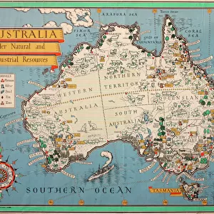
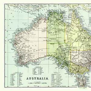
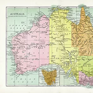
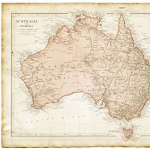
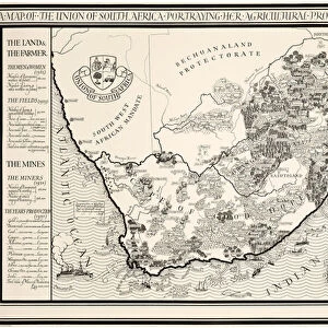
A Map of Australia, 1930 (colour litho)
")
![]()
Wall Art and Photo Gifts from Fine Art Finder
A Map of Australia, 1930 (colour litho)
1198399 A Map of Australia, 1930 (colour litho) by Gill, Leslie MacDonald (Max) (1884-1947); 102x153 cm; Private Collection; (add.info.: Gill, MacDonald (Max) (1884-1947)); Photo © Christies Images
Media ID 25212194
© Christie's Images / Bridgeman Images
1930 Capital Letter Classic Collectibles Collector Compass English Art English Artist English Text Fishing Industry Geographic Gill Green Colour Incopyright Information Land Language Leslie Macdonald Gill Lettering List Lithographic Lithoprint Macdonald Gill Max Gill Medium Group Medium Group Of Objects Navigational Equipment Patterned Printed Prints Striped Stripes Stripey Water Transport Water Vehicle Water Vessel Word Artist British British Artist Natural Space To Fish
FEATURES IN THESE COLLECTIONS
> Animals
> Fishes
> G
> Grouper
> Animals
> Fishes
> Related Images
> Animals
> Mammals
> Muridae
> Water Mouse
> Arts
> Artists
> Related Images
> Europe
> France
> Canton
> Landes
> Fine Art Finder
> Artists
> Leslie MacDonald (1884-1947) Gill
> Fine Art Finder
> Artists
> Pierre Felix Fix-Masseau
> Maps and Charts
> Early Maps
> Maps and Charts
> Related Images
> Oceania
> Australia
> Related Images
EDITORS COMMENTS
This vibrant and detailed print captures "A Map of Australia, 1930" by Leslie MacDonald Gill, also known as Max Gill. Measuring at an impressive 102x153 cm, this color lithograph showcases the artist's exceptional talent in cartography during the early twentieth century. The map itself is a visual feast for the eyes, with its rich green hues representing the lush landscapes of Australia. The coastline and shoreline are meticulously depicted, highlighting the country's strong maritime connections and fishing industry. Navigational equipment and ships can be seen scattered across the map, emphasizing Australia's history of trade and exploration. Gill's artistic prowess shines through his intricate lettering and attention to detail. The English text adds a touch of elegance to this European artist's work. The bold stripes that adorn parts of the map create a striking pattern that draws viewers' eyes towards different regions. As we delve into this mid-twentieth-century masterpiece, it becomes evident that it serves not only as an informative tool but also as a captivating piece of art. Its presence within any space would undoubtedly spark curiosity and ignite conversations about Australian history, agriculture, farming practices in the 1930s - all while showcasing Gill's incredible talent as an illustrator. This print offers us a glimpse into both historical cartography techniques and Max Gill's unique artistic style - making it a valuable addition to any collector or admirer of fine art prints.
MADE IN THE USA
Safe Shipping with 30 Day Money Back Guarantee
FREE PERSONALISATION*
We are proud to offer a range of customisation features including Personalised Captions, Color Filters and Picture Zoom Tools
SECURE PAYMENTS
We happily accept a wide range of payment options so you can pay for the things you need in the way that is most convenient for you
* Options may vary by product and licensing agreement. Zoomed Pictures can be adjusted in the Cart.