Home > Arts > Artists > B > Charles Marie Rigobert Bonne
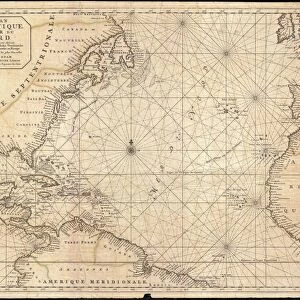
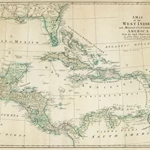
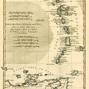
The Lesser Antilles or the Windward Islands, with the Eastern part of the Leeward Islands

![]()
Wall Art and Photo Gifts from Fine Art Finder
The Lesser Antilles or the Windward Islands, with the Eastern part of the Leeward Islands
KW205898 The Lesser Antilles or the Windward Islands, with the Eastern part of the Leeward Islands, from Atlas de Toutes les Parties Connues du Globe Terrestre by Guillaume Raynal (1713-96), published J L Pellet, Geneva, 1780 (coloured engraving) by Bonne, Charles Marie Rigobert (1727-95); Private Collection; Ken Welsh; French, out of copyright
Media ID 12755493
© www.bridgemanimages.com
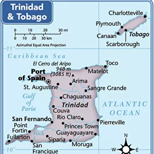
Caribbean Gulf Of Mexico Trinidad And Tobago West Indies
FEATURES IN THESE COLLECTIONS
> Arts
> Artists
> B
> Charles Marie Rigobert Bonne
> Fine Art Finder
> Artists
> Charles Marie Rigobert Bonne
> Fine Art Finder
> Maps (celestial & Terrestrial)
> Maps and Charts
> Related Images
> North America
> Mexico
> Maps
> North America
> Trinidad and Tobago
> Maps
EDITORS COMMENTS
This print showcases "The Lesser Antilles or the Windward Islands, with the Eastern part of the Leeward Islands" offering a glimpse into the rich history and geographical beauty of this Caribbean region. Created by Charles Marie Rigobert Bonne in 1780, this colored engraving is part of Guillaume Raynal's renowned Atlas de Toutes les Parties Connues du Globe Terrestre. The map takes us on a visual journey through the West Indies, specifically focusing on Trinidad and Tobago and its neighboring islands. The intricate details highlight each island's unique shape, while vibrant colors bring life to their lush landscapes. From St. Lucia to Barbados, Grenada to Dominica, these jewels of the Caribbean are beautifully depicted. As we explore this historic map, we can't help but imagine sailing through the crystal-clear waters that surround these idyllic islands. The Gulf of Mexico serves as a picturesque backdrop for this archipelago formation; its azure hues contrasting against the emerald green landmasses. This print not only captures our attention aesthetically but also sparks curiosity about the cultural heritage and natural wonders hidden within these tropical paradises. It invites us to delve deeper into their stories – tales of colonialism, indigenous peoples' resilience, and breathtaking biodiversity. With every glance at this remarkable artwork from Fine Art Finder via www. bridgemanimages. com, we are reminded of how art can transport us across time and space – allowing us to appreciate both historical significance and artistic
MADE IN THE USA
Safe Shipping with 30 Day Money Back Guarantee
FREE PERSONALISATION*
We are proud to offer a range of customisation features including Personalised Captions, Color Filters and Picture Zoom Tools
SECURE PAYMENTS
We happily accept a wide range of payment options so you can pay for the things you need in the way that is most convenient for you
* Options may vary by product and licensing agreement. Zoomed Pictures can be adjusted in the Cart.